
Magnitude |
:3.8 |
| Date & Time (UTC) | 2014-11-08 04:47:39.2 |
| Date & Time (Local) | 1393/8/17 08:17:39.2 |
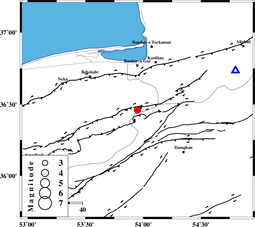
| Location | Lat:36.46 Lon: 53.95 |
| Region | Mazandaran Province, 34 km South of Bandar-e gaz |
Nearest Cities |
|
| 16 km South East of Bishehboneh, Mazandaran Province | |
| 17 km South of Sefid chah, Mazandaran Province | |
| 30 km South of Nokandeh, Golestan Province | |
| 31 km South of Gaz-e gharbi, Golestan Province | |
| 32 km South West of Sarkalateh, Golestan Province | |
| Depth | 15 km |
| Agency | |
Faults within 150 km: |
|
| N_ALBORZ_F (Length: 360 km) , Distance to epicenter: 5 km | |
| ASTANEH_F (Length: 72 km) , Distance to epicenter: 23 km | |
| KHAZAR_F (Length: 523 km) , Distance to epicenter: 29 km | |
| Number of Phases | 10 |
| RMS | 0.2 |
| Number of Stations | 8 |
| Error in Latitude | >4.6 km |
| Error in Longitude | 2.9 km |
| Error in Depth | 7.2 km |
Download waveform in seisan format
to download seisan software Click here
to access information about IIEES stations Click here
Amplitude | ||||||||
| UID | Agency | Station | Component | Amplitude | Period | Arrival Time | Proccessing Time | Signal Clip |
| 94232 | IIEES | THKV | N | 417.3 | 0.51 | 2014-11-08 04:49:01 | 2014-11-08 05:55:00 | n |
Phase | ||||||||||||
| Agency | Station | Component | Phase Type | Phase Quality | First Motion | Observed Arrival Time | Time Residual | Loc. Flag | Input Weight | Distance | Azimuth | |
| IIEES | CHTH | Z | Pn | E | 2014-11-08 04:48:19 | 0.14 | y | 261 | 257 | |||
| IIEES | CHTH | E | Sg | E | 2014-11-08 04:48:53 | 0.08 | y | 261 | 257 | |||
| IIEES | THKV | Z | Pn | E | 2014-11-08 04:48:22 | 0.06 | y | 283 | 259 | |||
| IIEES | THKV | N | Sg | E | 2014-11-08 04:48:58 | -0.1 | y | 283 | 259 | |||
| IIEES | GHVR | Z | Pn | E | 2014-11-08 04:48:27 | 0.01 | y | 329 | 229 | |||
| IIEES | BJRD | Z | Pn | E | 2014-11-08 04:48:28 | -0.18 | y | 337 | 65 | |||
| IIEES | ASAO | Z | Pn | E | 2014-11-08 04:48:38 | 0.02 | y | 414 | 240 | |||
| IIEES | NASN | Z | Pn | E | 2014-11-08 04:48:38 | -0.48 | y | 419 | 195 | |||
| IIEES | TABS | Z | Pn | E | 2014-11-08 04:48:40 | 0.43 | y | 425 | 136 | |||
| IIEES | SHRT | Z | Pn | E | 2014-11-08 04:49:08 | 0 | y | 657 | 117 | |||