
Magnitude |
:3.3 |
| Date & Time (UTC) | 2014-11-04 13:04:16.7 |
| Date & Time (Local) | 1393/8/13 16:34:16.7 |
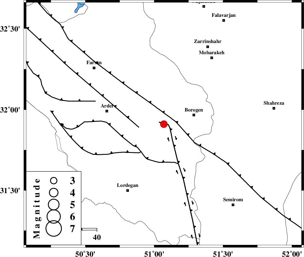
| Location | Lat:31.91 Lon: 51.07 |
| Region | Chaharmahal Bakhtiari Province, 21 km West of Borujen |
Nearest Cities |
|
| 3 km of Baladaji, Chaharmahal Bakhtiari Province | |
| 10 km North of Gandoman, Chaharmahal Bakhtiari Province | |
| 15 km West of Faradonbeh, Chaharmahal Bakhtiari Province | |
| 22 km West of Borujen, Chaharmahal Bakhtiari Province | |
| 26 km South West of Sefid-dasht, Chaharmahal Bakhtiari Province | |
| Depth | 14 km |
| Agency | |
Faults within 150 km: |
|
| DENA_F (Length: 137 km) , Distance to epicenter: 3 km | |
| MAIN_ZAGROS_R_F (Length: 1106 km) , Distance to epicenter: 8 km | |
| ARDAL_F (Length: 170 km) , Distance to epicenter: 17 km | |
| Number of Phases | 5 |
| RMS | 0.2 |
| Number of Stations | 4 |
| Error in Latitude | >13.7 km |
| Error in Longitude | 9.6 km |
| Error in Depth | 17.5 km |
Download waveform in seisan format
to download seisan software Click here
to access information about IIEES stations Click here
Amplitude | ||||||||
| UID | Agency | Station | Component | Amplitude | Period | Arrival Time | Proccessing Time | Signal Clip |
| 94194 | IIEES | KHMZ | E | 252.5 | 0.56 | 2014-11-04 13:05:30 | 2014-11-04 02:33:00 | n |
| 94195 | IIEES | GHVR | E | 98.8 | 0.64 | 2014-11-04 13:05:55 | 2014-11-04 02:33:00 | n |
Phase | ||||||||||||
| Agency | Station | Component | Phase Type | Phase Quality | First Motion | Observed Arrival Time | Time Residual | Loc. Flag | Input Weight | Distance | Azimuth | |
| IIEES | KHMZ | Z | Pn | E | 2014-11-04 13:04:52 | -0.11 | y | 228 | 333 | |||
| IIEES | GHVR | Z | Pn | E | 2014-11-04 13:05:00 | 0.29 | y | 285 | 3 | |||
| IIEES | ASAO | Z | Pn | E | 2014-11-04 13:05:02 | 0.01 | y | 308 | 342 | |||
| IIEES | ASAO | N | Sg | E | 2014-11-04 13:05:43 | -0.07 | y | 308 | 342 | |||
| IIEES | YZKH | Z | Pn | E | 2014-11-04 13:05:06 | -0.13 | y | 336 | 80 | |||