
Magnitude |
:5.3 |
| Date & Time (UTC) | 2014-10-24 12:38:56.9 |
| Date & Time (Local) | 1393/8/2 16:08:56.9 |
| Location | Lat:27.77 Lon: 57.4 |
| Region | Hormozgan Province, 41 km North of Manujan |
Nearest Cities |
|
| 13 km East of Fariab, Hormozgan Province | |
| 17 km North East of Ziaratali, Hormozgan Province | |
| 20 km North of Bejogan, Kerman Province | |
| 26 km North of Nodezh, Kerman Province | |
| 30 km North West of Bargah, Kerman Province | |
| Depth | 18 km |
| Agency | |
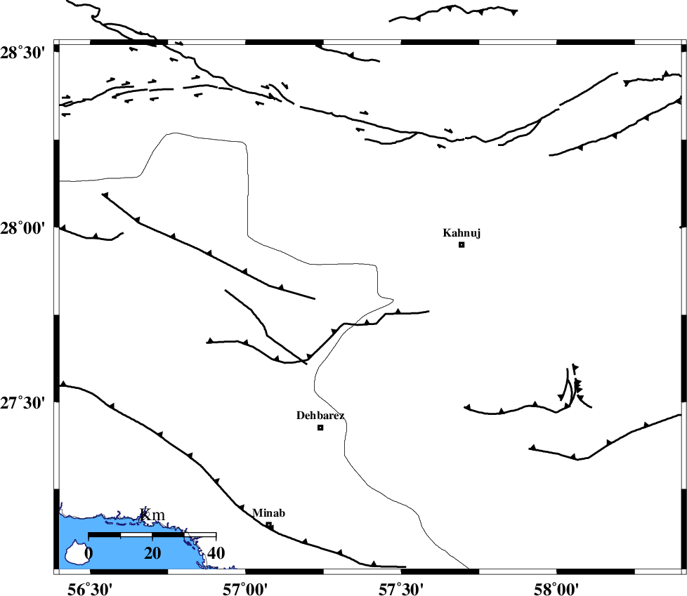
Faults within 150 km: |
|
| SABZEVARAN_F (Length: 190 km) , Distance to epicenter: 26 km | |
| JIROFT_F (Length: 144 km) , Distance to epicenter: 41 km | |
| ZENDAN_MINAB_F_Z1 (Length: 183 km) , Distance to epicenter: 45 km | |
| Number of Phases | 6 |
| RMS | 0.1 |
| Number of Stations | 4 |
| Error in Latitude | >3.1 km |
| Error in Longitude | 5 km |
| Error in Depth | 3.6 km |
Download waveform in seisan format
to download seisan software Click here
to access information about IIEES stations Click here
Amplitude | ||||||||
| UID | Agency | Station | Component | Amplitude | Period | Arrival Time | Proccessing Time | Signal Clip |
| 94068 | IIEES | BNDS | N | 59276.8 | 0.4 | 2014-10-24 12:39:38 | 2014-10-24 01:01:00 | n |
| 94069 | IIEES | KRBR | N | 16186 | 0.44 | 2014-10-24 12:40:11 | 2014-10-24 01:01:00 | n |
Phase | ||||||||||||
| Agency | Station | Component | Phase Type | Phase Quality | First Motion | Observed Arrival Time | Time Residual | Loc. Flag | Input Weight | Distance | Azimuth | |
| IIEES | BNDS | Z | Pg | E | 2014-10-24 12:39:18 | 0.02 | y | 128 | 252 | |||
| IIEES | KRBR | Z | Pn | E | 2014-10-24 12:39:35 | -0.11 | y | 253 | 346 | |||
| IIEES | BSRN | Z | Pn | E | 2014-10-24 12:40:05 | 0.04 | y | 494 | 19 | |||
| IIEES | BSRN | E | Sg | E | 2014-10-24 12:41:14 | 0.03 | y | 494 | 19 | |||
| IIEES | TABS | Z | Pn | E | 2014-10-24 12:40:25 | 0.15 | y | 652 | 358 | |||
| IIEES | TABS | E | Sg | E | 2014-10-24 12:41:57 | -0.06 | y | 652 | 358 | |||