
Magnitude |
:2.9 |
| Date & Time (UTC) | 2014-10-21 08:20:16.8 |
| Date & Time (Local) | 1393/7/29 11:50:16.8 |
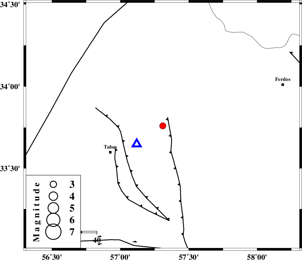
| Location | Lat:33.76 Lon: 57.31 |
| Region | Khorasan(center) Province, 39 km North-East of Tabas |
Nearest Cities |
|
| 8 km of Reqqeh, Khorasan(center) Province | |
| 10 km North of Arsak, Khorasan(center) Province | |
| 16 km South West of Boshravieh, Khorasan(center) Province | |
| 31 km South of Qaniabad, Khorasan(center) Province | |
| 40 km North East of Tabas, Yazd Province | |
| Depth | 14 km |
| Agency | |
Faults within 150 km: |
|
| ESFARDIAR_F (Length: 94 km) , Distance to epicenter: 7 km | |
| TABAS_F1 (Length: 91 km) , Distance to epicenter: 29 km | |
| TABAS_F2 (Length: 67 km) , Distance to epicenter: 35 km | |
| Number of Phases | 6 |
| RMS | 0.3 |
| Number of Stations | 4 |
| Error in Latitude | >6.9 km |
| Error in Longitude | 3.3 km |
| Error in Depth | 7 km |
Download waveform in seisan format
to download seisan software Click here
to access information about IIEES stations Click here
Amplitude | ||||||||
| UID | Agency | Station | Component | Amplitude | Period | Arrival Time | Proccessing Time | Signal Clip |
| 94041 | IIEES | TABS | N | 2136.4 | 0.5 | 2014-10-21 08:20:28 | 2014-10-21 08:52:00 | n |
Phase | ||||||||||||
| Agency | Station | Component | Phase Type | Phase Quality | First Motion | Observed Arrival Time | Time Residual | Loc. Flag | Input Weight | Distance | Azimuth | |
| IIEES | TABS | Z | Pg | E | 2014-10-21 08:20:20 | -0.49 | y | 21.3 | 235 | |||
| IIEES | BSRN | Z | Pn | E | 2014-10-21 08:20:57 | 0.54 | y | 262 | 139 | |||
| IIEES | BSRN | N | Sg | E | 2014-10-21 08:21:30 | -0.18 | y | 262 | 139 | |||
| IIEES | SHRT | Z | Pn | E | 2014-10-21 08:20:58 | -0.19 | y | 277 | 92 | |||
| IIEES | YZKH | Z | Pn | E | 2014-10-21 08:21:01 | 0.24 | y | 295 | 240 | |||
| IIEES | YZKH | E | Sg | E | 2014-10-21 08:21:40 | 0.1 | y | 295 | 240 | |||