
Magnitude |
:3.4 |
| Date & Time (UTC) | 2014-10-04 05:43:11.3 |
| Date & Time (Local) | 1393/7/12 09:13:11.3 |
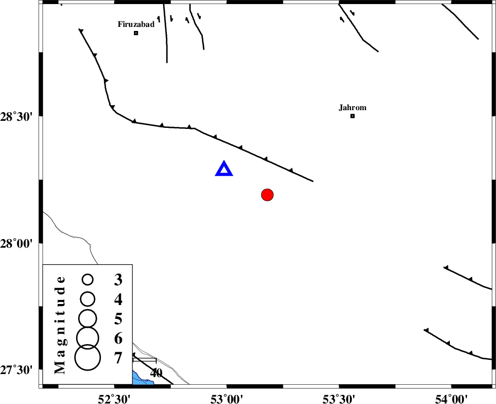
| Location | Lat:28.19 Lon: 53.18 |
| Region | Fars Province, 34 km South-East of Qir va Karzin |
Nearest Cities |
|
| 5 km North of Seyfabad, Fars Province | |
| 24 km South West of Mobarakabad, Fars Province | |
| 27 km South East of Shahrak-e jonubi, Fars Province | |
| 33 km South of Fathabad, Fars Province | |
| 34 km South East of Qir va Karzin, Fars Province | |
| Depth | 14 km |
| Agency | |
Faults within 150 km: |
|
| QIR_F (Length: 130 km) , Distance to epicenter: 21 km | |
| SABZ_PUSHAN_F_Z2 (Length: 24 km) , Distance to epicenter: 69 km | |
| SABZ_PUSHAN_F_Z1 (Length: 69 km) , Distance to epicenter: 72 km | |
| Number of Phases | 6 |
| RMS | 0.1 |
| Number of Stations | 5 |
| Error in Latitude | >6.7 km |
| Error in Longitude | 2.6 km |
| Error in Depth | 8.4 km |
Download waveform in seisan format
to download seisan software Click here
to access information about IIEES stations Click here
Amplitude | ||||||||
| UID | Agency | Station | Component | Amplitude | Period | Arrival Time | Proccessing Time | Signal Clip |
| 93756 | IIEES | AHRM | E | 404.7 | 0.53 | 2014-10-04 05:44:10 | 2014-10-04 06:19:00 | n |
| 93757 | IIEES | AHRM | N | 388.6 | 0.32 | 2014-10-04 05:44:11 | 2014-10-04 06:19:00 | n |
Phase | ||||||||||||
| Agency | Station | Component | Phase Type | Phase Quality | First Motion | Observed Arrival Time | Time Residual | Loc. Flag | Input Weight | Distance | Azimuth | |
| IIEES | AHRM | Z | Pn | E | 2014-10-04 05:43:43 | 0.04 | y | 199 | 293 | |||
| IIEES | AHRM | N | Sg | E | 2014-10-04 05:44:07 | -0.04 | y | 199 | 293 | |||
| IIEES | KRBR | Z | Pn | E | 2014-10-04 05:44:09 | -0.07 | y | 401 | 59 | |||
| IIEES | YZKH | Z | Pn | E | 2014-10-04 05:44:19 | 0.19 | y | 485 | 16 | |||
| IIEES | TABS | Z | Pn | E | 2014-10-04 05:44:47 | -0.24 | y | 713 | 31 | |||
| IIEES | ZHSF | Z | Pn | E | 2014-10-04 05:44:53 | 0.06 | y | 757 | 76 | |||