
Magnitude |
:3 |
| Date & Time (UTC) | 2014-09-23 07:39:25.4 |
| Date & Time (Local) | 1393/7/1 11:09:25.4 |
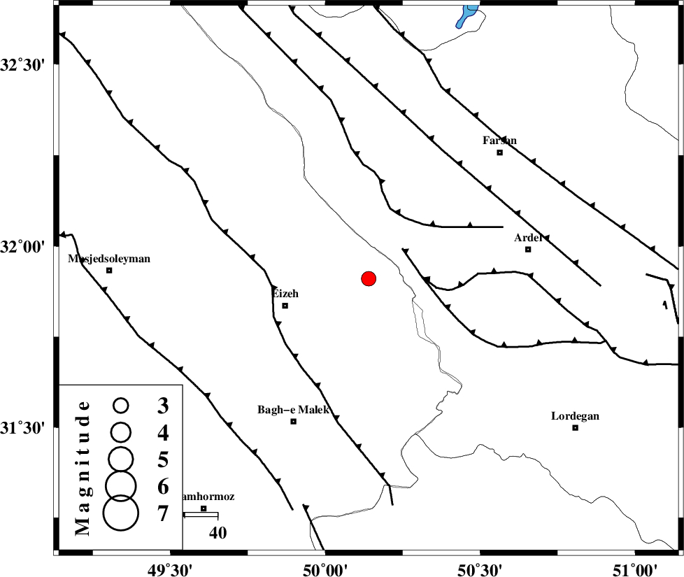
| Location | Lat:31.91 Lon: 50.14 |
| Region | Khoozestan Province, 27 km East of Izeh |
Nearest Cities |
|
| 22 km North West of Dehdez, Khoozestan Province | |
| 27 km North East of Izeh, Khoozestan Province | |
| 31 km East of Torshak, Khoozestan Province | |
| 32 km North East of Rasvand, Khoozestan Province | |
| 37 km North East of Chenarestan, Khoozestan Province | |
| Depth | 15 km |
| Agency | |
Faults within 150 km: |
|
| DOPOLAN_F (Length: 107 km) , Distance to epicenter: 14 km | |
| SABZKUH_F (Length: 67 km) , Distance to epicenter: 16 km | |
| ZARDKUH_F (Length: 139 km) , Distance to epicenter: 22 km | |
| Number of Phases | 8 |
| RMS | 0.2 |
| Number of Stations | 6 |
| Error in Latitude | >2.9 km |
| Error in Longitude | 9 km |
| Error in Depth | 8.3 km |
Download waveform in seisan format
to download seisan software Click here
to access information about IIEES stations Click here
Amplitude | ||||||||
| UID | Agency | Station | Component | Amplitude | Period | Arrival Time | Proccessing Time | Signal Clip |
| 93665 | IIEES | DAMV | E | 19.1 | 0.34 | 2014-09-23 07:41:29 | 2014-09-23 09:19:00 | n |
Phase | ||||||||||||
| Agency | Station | Component | Phase Type | Phase Quality | First Motion | Observed Arrival Time | Time Residual | Loc. Flag | Input Weight | Distance | Azimuth | |
| IIEES | KHMZ | Z | Pg | E | 2014-09-23 07:39:58 | 0.02 | y | 203 | 355 | |||
| IIEES | KHMZ | E | Sg | E | 2014-09-23 07:40:23 | 0.19 | y | 203 | 355 | |||
| IIEES | ASAO | Z | Pn | E | 2014-09-23 07:40:09 | 0.24 | y | 292 | 358 | |||
| IIEES | ASAO | E | Sg | E | 2014-09-23 07:40:47 | -0.23 | y | 292 | 358 | |||
| IIEES | AHRM | Z | Pn | E | 2014-09-23 07:40:17 | 0.02 | y | 356 | 162 | |||
| IIEES | YZKH | Z | Pn | E | 2014-09-23 07:40:26 | 0.29 | y | 423 | 82 | |||
| IIEES | DAMV | Z | Pn | E | 2014-09-23 07:40:28 | -0.46 | y | 446 | 22 | |||
| IIEES | GHIR | Z | Pn | E | 2014-09-23 07:40:33 | -0.18 | y | 487 | 145 | |||