
Magnitude |
:2.5 |
| Date & Time (UTC) | 2014-09-16 07:25:02.1 |
| Date & Time (Local) | 1393/6/25 11:55:02.1 |
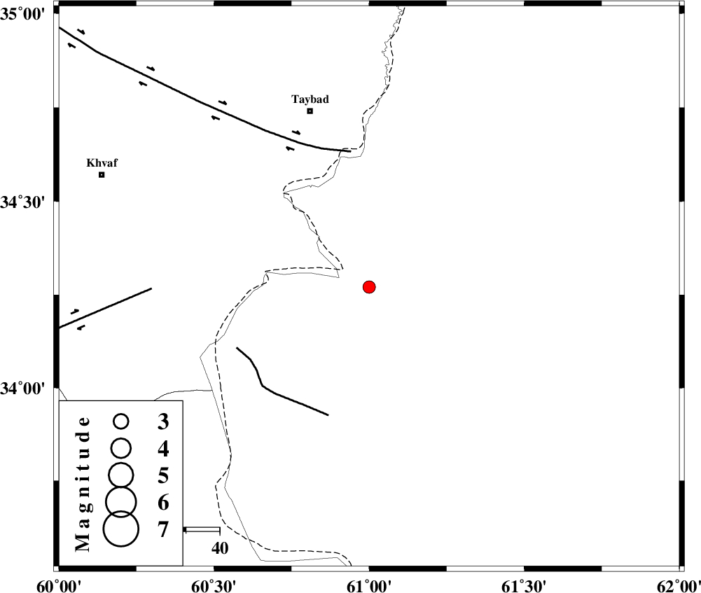
| Location | Lat:34.27 Lon: 61 |
| Region | Afghanistan, 55 km South-East of Taybad |
Nearest Cities |
|
| 52 km South East of Karat, Khorasan(center) Province | |
| 55 km South East of Taybad, Khorasan(center) Province | |
| 56 km North East of Chahkand, Khorasan(center) Province | |
| 62 km South East of Void, Khorasan(center) Province | |
| 67 km North East of Sirkhun, Khorasan(center) Province | |
| Depth | 14 km |
| Agency | |
Faults within 150 km: |
|
| DORUNEH_F (Length: 713 km) , Distance to epicenter: 41 km | |
| DASHT_E_BAYAZ_F (Length: 177 km) , Distance to epicenter: 64 km | |
| PATARGAN_F (Length: 52 km) , Distance to epicenter: 80 km | |
| Number of Phases | 4 |
| RMS | 0.1 |
| Number of Stations | 4 |
| Error in Latitude | >5.5 km |
| Error in Longitude | 8 km |
| Error in Depth | 6.9 km |
Download waveform in seisan format
to download seisan software Click here
to access information about IIEES stations Click here
Amplitude | ||||||||
| UID | Agency | Station | Component | Amplitude | Period | Arrival Time | Proccessing Time | Signal Clip |
| 93600 | IIEES | TABS | N | 3.2 | 0.66 | 2014-09-16 07:25:59 | 2014-09-16 09:34:00 | n |
| 93601 | IIEES | KRBR | N | 3.8 | 0.4 | 2014-09-16 07:24:30 | 2014-09-16 09:34:00 | n |
| 93602 | IIEES | KRBR | E | 5.3 | 0.2 | 2014-09-16 07:24:31 | 2014-09-16 09:34:00 | n |
Phase | ||||||||||||
| Agency | Station | Component | Phase Type | Phase Quality | First Motion | Observed Arrival Time | Time Residual | Loc. Flag | Input Weight | Distance | Azimuth | |
| IIEES | SHRT | Z | Pg | E | 2014-09-16 07:25:18 | -0.17 | y | 95.3 | 223 | |||
| IIEES | SHRT | N | Sg | E | 2014-09-16 07:25:30 | 0.05 | y | 95.3 | 223 | |||
| IIEES | BSRN | Z | Pn | E | 2014-09-16 07:25:48 | 0.11 | y | 310 | 215 | |||
| IIEES | TABS | Z | Pn | E | 2014-09-16 07:25:55 | 0.03 | y | 365 | 260 | |||