
Magnitude |
:3.8 |
| Date & Time (UTC) | 2014-09-09 08:41:46.9 |
| Date & Time (Local) | 1393/6/18 13:11:46.9 |
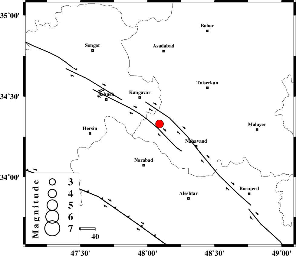
| Location | Lat:34.33 Lon: 48.09 |
| Region | Hamedan Province, 23 km South-East of Kangavar |
Nearest Cities |
|
| 7 km of Firuzan, Hamedan Province | |
| 8 km North of Shahrak, Hamedan Province | |
| 19 km South East of Karmanjan, Kermanshah Province | |
| 20 km North West of Barzul, Hamedan Province | |
| 20 km East of Sarab dehlor, Kermanshah Province | |
| Depth | 14 km |
| Agency | |
Faults within 150 km: |
|
| SAHANEH_F (Length: 77 km) , Distance to epicenter: 3 km | |
| NAHAVAND_F (Length: 102 km) , Distance to epicenter: 8 km | |
| DINEHVAR_F (Length: 46 km) , Distance to epicenter: 31 km | |
| Number of Phases | 6 |
| RMS | 0.2 |
| Number of Stations | 5 |
| Error in Latitude | >2.3 km |
| Error in Longitude | 3.4 km |
| Error in Depth | 8.3 km |
Download waveform in seisan format
to download seisan software Click here
to access information about IIEES stations Click here
Amplitude | ||||||||
| UID | Agency | Station | Component | Amplitude | Period | Arrival Time | Proccessing Time | Signal Clip |
| 93553 | IIEES | SHGR | E | 769.8 | 0.6 | 2014-09-09 08:43:04 | 2014-09-14 07:54:00 | n |
| 93554 | IIEES | SHGR | N | 453.1 | 0.43 | 2014-09-09 08:43:08 | 2014-09-14 07:54:00 | n |
Phase | ||||||||||||
| Agency | Station | Component | Phase Type | Phase Quality | First Motion | Observed Arrival Time | Time Residual | Loc. Flag | Input Weight | Distance | Azimuth | |
| IIEES | SNGE | Z | Pg | E | 2014-09-09 08:42:05 | 0.12 | y | 109 | 322 | |||
| IIEES | SNGE | N | Sg | E | 2014-09-09 08:42:18 | -0.14 | y | 109 | 322 | |||
| IIEES | ASAO | Z | Pg | E | 2014-09-09 08:42:16 | -0.13 | y | 180 | 82 | |||
| IIEES | KHMZ | Z | Pg | E | 2014-09-09 08:42:17 | -0.27 | y | 185 | 110 | |||
| IIEES | SHGR | N | Sg | E | 2014-09-09 08:42:58 | 0.06 | y | 255 | 165 | |||
| IIEES | DAMV | Z | Pn | E | 2014-09-09 08:42:42 | 0.45 | y | 383 | 67 | |||