
Magnitude |
:3 |
| Date & Time (UTC) | 2014-09-03 23:26:52.5 |
| Date & Time (Local) | 1393/6/13 03:56:52.5 |
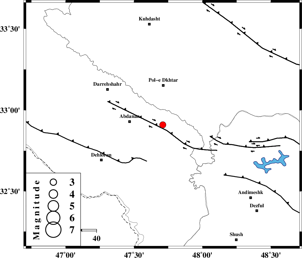
| Location | Lat:32.91 Lon: 47.71 |
| Region | Ilam Province, 27 km South of Pol-e dokhtar |
Nearest Cities |
|
| 14 km North East of Sarabbagh, Ilam Province | |
| 21 km South of Sarab hammam, Lorestan Province | |
| 23 km East of Abdanan, Ilam Province | |
| 27 km South of Pol-e dokhtar, Lorestan Province | |
| 37 km South of Morani, Lorestan Province | |
| Depth | 14 km |
| Agency | |
Faults within 150 km: |
|
| BALARUD_F_Z1 (Length: 87 km) , Distance to epicenter: 5 km | |
| MFF6 (Length: 144 km) , Distance to epicenter: 27 km | |
| BALARUD_F_Z3 (Length: 53 km) , Distance to epicenter: 33 km | |
| Number of Phases | 6 |
| RMS | 0.2 |
| Number of Stations | 4 |
| Error in Latitude | >2.5 km |
| Error in Longitude | 6.5 km |
| Error in Depth | 9 km |
Download waveform in seisan format
to download seisan software Click here
to access information about IIEES stations Click here
Amplitude | ||||||||
| UID | Agency | Station | Component | Amplitude | Period | Arrival Time | Proccessing Time | Signal Clip |
| 93460 | IIEES | SHGR | N | 276.9 | 0.84 | 2014-09-03 23:27:34 | 2014-09-04 03:57:00 | n |
Phase | ||||||||||||
| Agency | Station | Component | Phase Type | Phase Quality | First Motion | Observed Arrival Time | Time Residual | Loc. Flag | Input Weight | Distance | Azimuth | |
| IIEES | SHGR | Z | Pg | E | 2014-09-03 23:27:14 | -0.34 | y | 136 | 131 | |||
| IIEES | SHGR | E | Sg | E | 2014-09-03 23:27:31 | 0.16 | y | 136 | 131 | |||
| IIEES | KHMZ | Z | Pn | E | 2014-09-03 23:27:29 | 0.36 | y | 229 | 66 | |||
| IIEES | SNGE | Z | Pn | E | 2014-09-03 23:27:30 | -0.14 | y | 244 | 352 | |||
| IIEES | ASAO | Z | Pn | E | 2014-09-03 23:27:35 | 0.14 | y | 281 | 49 | |||
| IIEES | ASAO | N | Sg | E | 2014-09-03 23:28:11 | -0.18 | y | 281 | 49 | |||