
Magnitude |
:3.2 |
| Date & Time (UTC) | 2014-08-27 15:40:54.9 |
| Date & Time (Local) | 1393/6/5 20:10:54.9 |
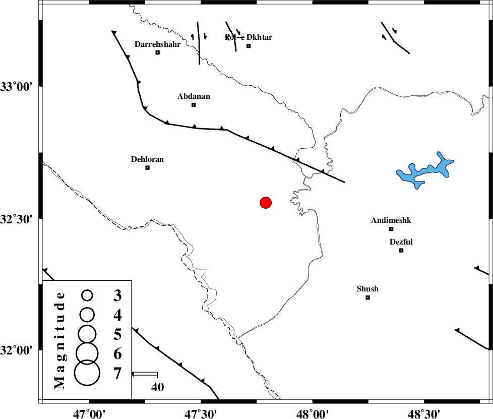
| Location | Lat:32.56 Lon: 47.79 |
| Region | Ilam Province, 52 km South-East of Dehloran |
Nearest Cities |
|
| 40 km North East of Musian, Ilam Province | |
| 43 km South East of Sarabbagh, Ilam Province | |
| 45 km South West of Hoseinieh, Khoozestan Province | |
| 47 km South West of Bidruyeh, Khoozestan Province | |
| 51 km South East of Abdanan, Ilam Province | |
| Depth | 14 km |
| Agency | |
Faults within 150 km: |
|
| MFF6 (Length: 144 km) , Distance to epicenter: 23 km | |
| BALARUD_F_Z1 (Length: 87 km) , Distance to epicenter: 26 km | |
| DEZFUL_EMBAYMENT (Length: 228 km) , Distance to epicenter: 35 km | |
| Number of Phases | 6 |
| RMS | 0.1 |
| Number of Stations | 5 |
| Error in Latitude | >1.7 km |
| Error in Longitude | 5.3 km |
| Error in Depth | 6.1 km |
Download waveform in seisan format
to download seisan software Click here
to access information about IIEES stations Click here
Amplitude | ||||||||
| UID | Agency | Station | Component | Amplitude | Period | Arrival Time | Proccessing Time | Signal Clip |
| 93353 | IIEES | GHIR | E | 7.2 | 0.08 | 2014-08-27 15:42:44 | 2014-08-27 05:03:00 | n |
Phase | ||||||||||||
| Agency | Station | Component | Phase Type | Phase Quality | First Motion | Observed Arrival Time | Time Residual | Loc. Flag | Input Weight | Distance | Azimuth | |
| IIEES | SHGR | Z | Pg | E | 2014-08-27 15:41:12 | -0.13 | y | 108 | 118 | |||
| IIEES | SHGR | E | Sg | E | 2014-08-27 15:41:26 | 0.08 | y | 108 | 118 | |||
| IIEES | KHMZ | Z | Pn | E | 2014-08-27 15:41:32 | -0.04 | y | 241 | 57 | |||
| IIEES | KHMZ | Z | Sg | E | 2014-08-27 15:42:03 | -0.04 | y | 241 | 57 | |||
| IIEES | ASAO | Z | Pn | E | 2014-08-27 15:41:40 | 0.07 | y | 302 | 43 | |||
| IIEES | GHVR | Z | Pn | E | 2014-08-27 15:41:50 | 0.08 | y | 385 | 56 | |||