
Magnitude |
:3.2 |
| Date & Time (UTC) | 2014-08-24 15:14:16.7 |
| Date & Time (Local) | 1393/6/2 19:44:16.7 |
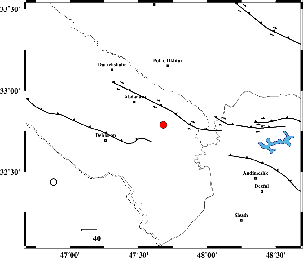
| Location | Lat:32.79 Lon: 47.68 |
| Region | Ilam Province, 25 km South-East of Abdanan |
Nearest Cities |
|
| 16 km South East of Sarabbagh, Ilam Province | |
| 25 km South East of Abdanan, Ilam Province | |
| 34 km South of Sarab hammam, Lorestan Province | |
| 40 km North East of Musian, Ilam Province | |
| 40 km South of Pol-e dokhtar, Lorestan Province | |
| Depth | 16 km |
| Agency | |
Faults within 150 km: |
|
| BALARUD_F_Z1 (Length: 87 km) , Distance to epicenter: 11 km | |
| MFF6 (Length: 144 km) , Distance to epicenter: 14 km | |
| BALARUD_F_Z3 (Length: 53 km) , Distance to epicenter: 35 km | |
| Number of Phases | 7 |
| RMS | 0 |
| Number of Stations | 5 |
| Error in Latitude | >1.5 km |
| Error in Longitude | 4.1 km |
| Error in Depth | 4.9 km |
Download waveform in seisan format
to download seisan software Click here
to access information about IIEES stations Click here
Amplitude | ||||||||
| UID | Agency | Station | Component | Amplitude | Period | Arrival Time | Proccessing Time | Signal Clip |
| 93269 | IIEES | SHGR | E | 633.9 | 0.64 | 2014-08-24 15:14:58 | 2014-08-24 04:38:00 | n |
| 93270 | IIEES | SHGR | N | 443.8 | 0.6 | 2014-08-24 15:15:02 | 2014-08-24 04:38:00 | n |
| 93271 | IIEES | ASAO | N | 68.7 | 0.6 | 2014-08-24 15:15:44 | 2014-08-24 04:38:00 | n |
Phase | ||||||||||||
| Agency | Station | Component | Phase Type | Phase Quality | First Motion | Observed Arrival Time | Time Residual | Loc. Flag | Input Weight | Distance | Azimuth | |
| IIEES | SHGR | Z | Pg | E | 2014-08-24 15:14:38 | -0.01 | y | 130 | 125 | |||
| IIEES | SHGR | E | Sg | E | 2014-08-24 15:14:54 | 0.01 | y | 130 | 125 | |||
| IIEES | KHMZ | Z | Pn | E | 2014-08-24 15:14:53 | -0.04 | y | 238 | 63 | |||
| IIEES | KHMZ | Z | Sg | E | 2014-08-24 15:15:24 | 0 | y | 238 | 63 | |||
| IIEES | ASAO | Z | Pn | E | 2014-08-24 15:15:00 | 0.06 | y | 293 | 47 | |||
| IIEES | GHVR | Z | Pn | E | 2014-08-24 15:15:11 | 0 | y | 381 | 59 | |||
| IIEES | CHTH | Z | Pn | E | 2014-08-24 15:15:22 | -0.02 | y | 470 | 42 | |||