
Magnitude |
:5.4 |
| Date & Time (UTC) | 2014-08-23 20:05:20.5 |
| Date & Time (Local) | 1393/6/2 00:35:20.5 |
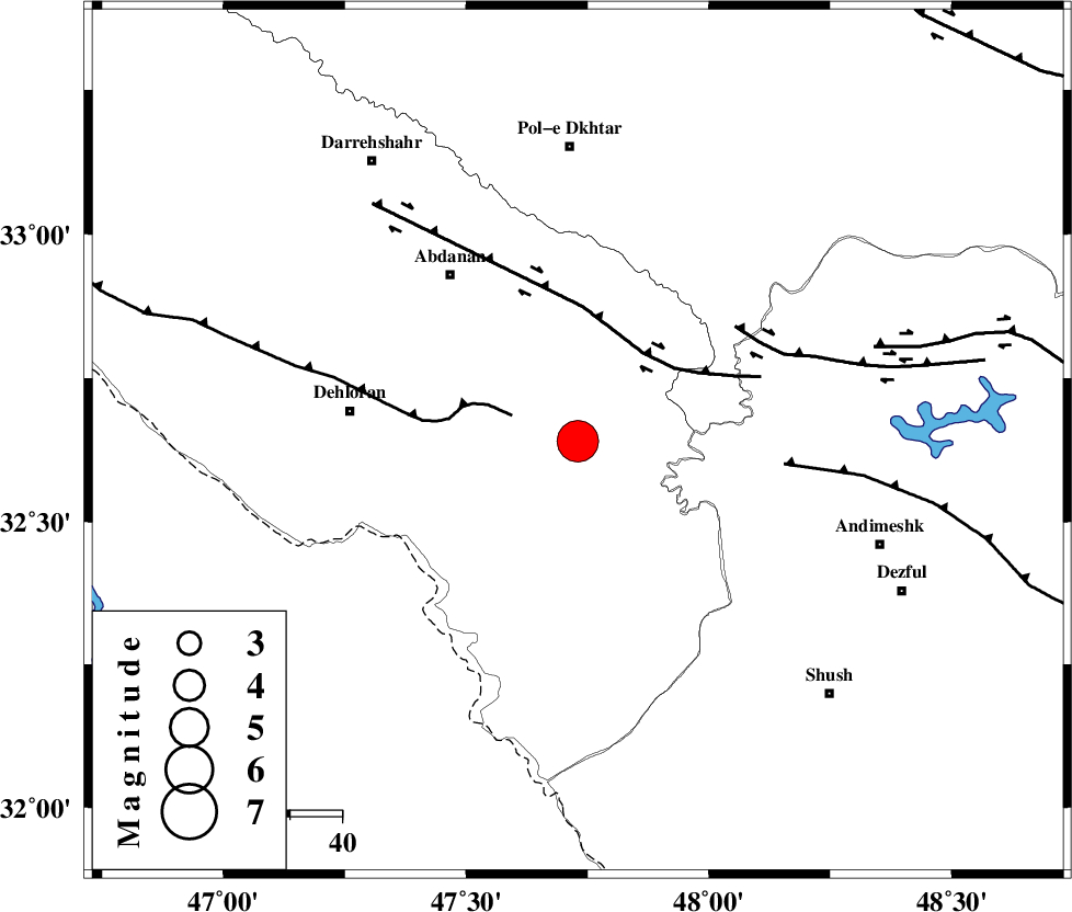
| Location | Lat:32.64 Lon: 47.73 |
| Region | Ilam Province, 44 km East of Dehloran |
Nearest Cities |
|
| 33 km South East of Sarabbagh, Ilam Province | |
| 36 km North East of Musian, Ilam Province | |
| 40 km South East of Abdanan, Ilam Province | |
| 44 km East of Dehloran, Ilam Province | |
| 49 km West of Hoseinieh, Khoozestan Province | |
| Depth | 40 km |
| Agency | |
Faults within 150 km: |
|
| MFF6 (Length: 144 km) , Distance to epicenter: 14 km | |
| BALARUD_F_Z1 (Length: 87 km) , Distance to epicenter: 21 km | |
| BALARUD_F_Z3 (Length: 53 km) , Distance to epicenter: 38 km | |
| Number of Phases | 9 |
| RMS | 0.2 |
| Number of Stations | 8 |
| Error in Latitude | >3.8 km |
| Error in Longitude | 6.5 km |
| Error in Depth | 2.9 km |
Download waveform in seisan format
to download seisan software Click here
to access information about IIEES stations Click here
Amplitude | ||||||||
| UID | Agency | Station | Component | Amplitude | Period | Arrival Time | Proccessing Time | Signal Clip |
| 93244 | IIEES | SNGE | N | 10715.6 | 0.52 | 2014-08-23 20:06:39 | 2014-08-23 09:32:00 | n |
| 93245 | IIEES | AHRM | E | 4775.2 | 0.56 | 2014-08-23 20:08:10 | 2014-08-23 09:32:00 | n |
Phase | ||||||||||||
| Agency | Station | Component | Phase Type | Phase Quality | First Motion | Observed Arrival Time | Time Residual | Loc. Flag | Input Weight | Distance | Azimuth | |
| IIEES | SHGR | Z | Pg | E | 2014-08-23 20:05:40 | -0.13 | y | 117 | 120 | |||
| IIEES | SHGR | E | Sg | E | 2014-08-23 20:05:54 | 0.08 | y | 117 | 120 | |||
| IIEES | KHMZ | Z | Pn | E | 2014-08-23 20:05:56 | 0.29 | y | 242 | 59 | |||
| IIEES | SNGE | Z | Pn | E | 2014-08-23 20:06:00 | 0.05 | y | 275 | 353 | |||
| IIEES | SNGE | N | Sg | E | 2014-08-23 20:06:36 | 0.02 | y | 275 | 353 | |||
| IIEES | CHTH | Z | Pn | E | 2014-08-23 20:06:25 | -0.35 | y | 479 | 40 | |||
| IIEES | DAMV | Z | Pn | E | 2014-08-23 20:06:29 | -0.04 | y | 513 | 49 | |||
| IIEES | GRMI | Z | Pn | E | 2014-08-23 20:06:51 | 0.07 | y | 685 | 1 | |||
| IIEES | TABS | Z | Pn | E | 2014-08-23 20:07:15 | -0.24 | y | 883 | 80 | |||