
Magnitude |
:5 |
| Date & Time (UTC) | 2014-08-22 20:06:05.4 |
| Date & Time (Local) | 1393/6/1 00:36:05.4 |
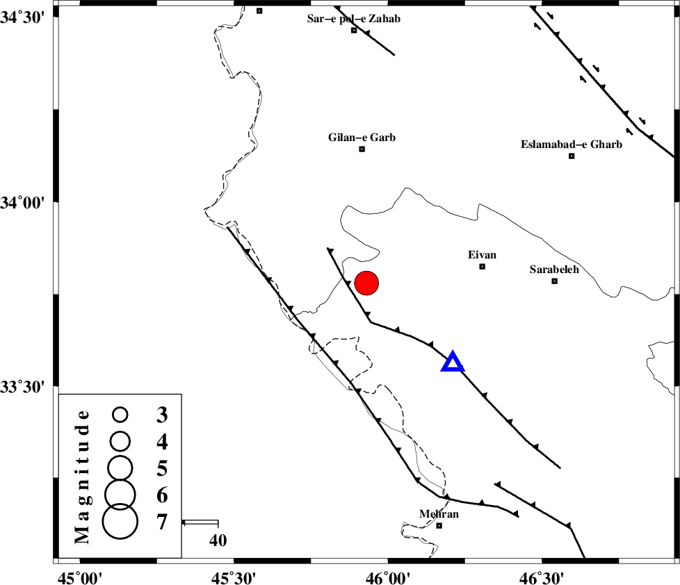
| Location | Lat:33.78 Lon: 45.93 |
| Region | Ilam Province, 41 km South of Gilan-E-Gharb |
Nearest Cities |
|
| 26 km South West of Teran, Ilam Province | |
| 28 km South of Nian, Kermanshah Province | |
| 28 km South West of Zarneh, Ilam Province | |
| 29 km East of Sumar, Kermanshah Province | |
| 33 km North West of Chavar, Ilam Province | |
| Depth | 15 km |
| Agency | |
Faults within 150 km: |
|
| MFF7 (Length: 99 km) , Distance to epicenter: 7 km | |
| ZFF4 (Length: 128 km) , Distance to epicenter: 23 km | |
| MFF8 (Length: 48 km) , Distance to epicenter: 69 km | |
| Number of Phases | 5 |
| RMS | 0 |
| Number of Stations | 6 |
| Error in Latitude | >2.6 km |
| Error in Longitude | 5.7 km |
| Error in Depth | 0 km |
Download waveform in seisan format
to download seisan software Click here
to access information about IIEES stations Click here
Amplitude | ||||||||
| UID | Agency | Station | Component | Amplitude | Period | Arrival Time | Proccessing Time | Signal Clip |
| 93214 | IIEES | SHGR | N | 4581.5 | 0.72 | 2014-08-22 20:07:58 | 2014-08-22 09:28:00 | n |
| 93215 | IIEES | SHGR | E | 3521.7 | 0.52 | 2014-08-22 20:07:59 | 2014-08-22 09:28:00 | n |
| 93216 | IIEES | AHRM | E | 303.7 | 0.6 | 2014-08-22 20:10:02 | 2014-08-22 09:28:00 | n |
| 93217 | IIEES | AHRM | N | 344.4 | 0.56 | 2014-08-22 20:10:06 | 2014-08-22 09:28:00 | n |
Phase | ||||||||||||
| Agency | Station | Component | Phase Type | Phase Quality | First Motion | Observed Arrival Time | Time Residual | Loc. Flag | Input Weight | Distance | Azimuth | |
| IIEES | SHGR | Z | Pn | E | 2014-08-22 20:06:53 | 0.01 | y | 326 | 124 | |||
| IIEES | KHMZ | Z | Pn | E | 2014-08-22 20:06:59 | -0.06 | y | 374 | 90 | |||
| IIEES | ZNJK | Z | Pn | E | 2014-08-22 20:07:03 | -0.02 | y | 407 | 37 | |||
| IIEES | CHTH | Z | Pn | E | 2014-08-22 20:07:19 | 0.05 | y | 531 | 62 | |||
| IIEES | DAMV | Z | Pn | E | 2014-08-22 20:07:26 | 0.04 | y | 590 | 68 | |||