
Magnitude |
:3 |
| Date & Time (UTC) | 2014-08-19 22:07:25.6 |
| Date & Time (Local) | 1393/5/29 02:37:25.6 |
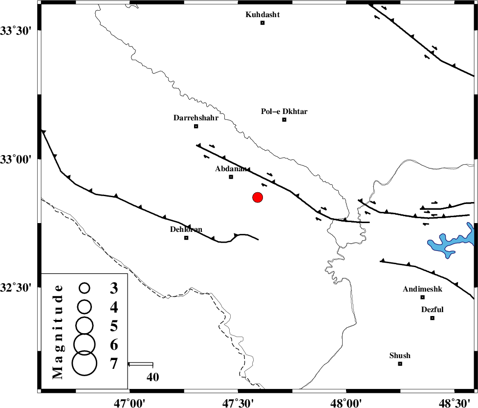
| Location | Lat:32.85 Lon: 47.59 |
| Region | Ilam Province, 14 km East of Abdanan |
Nearest Cities |
|
| 6 km of Sarabbagh, Ilam Province | |
| 14 km East of Abdanan, Ilam Province | |
| 29 km South of Sarab hammam, Lorestan Province | |
| 35 km North East of Dehloran, Ilam Province | |
| 36 km South West of Pol-e dokhtar, Lorestan Province | |
| Depth | 14 km |
| Agency | |
Faults within 150 km: |
|
| BALARUD_F_Z1 (Length: 87 km) , Distance to epicenter: 14 km | |
| MFF6 (Length: 144 km) , Distance to epicenter: 17 km | |
| BALARUD_F_Z3 (Length: 53 km) , Distance to epicenter: 43 km | |
| Number of Phases | 8 |
| RMS | 0 |
| Number of Stations | 7 |
| Error in Latitude | >13.4 km |
| Error in Longitude | 7.2 km |
| Error in Depth | 20.2 km |
Download waveform in seisan format
to download seisan software Click here
to access information about IIEES stations Click here
Amplitude | ||||||||
| UID | Agency | Station | Component | Amplitude | Period | Arrival Time | Proccessing Time | Signal Clip |
| 93150 | IIEES | AHRM | N | 9.8 | 0.48 | 2014-08-19 22:09:37 | 2014-08-20 12:10:00 | n |
Phase | ||||||||||||
| Agency | Station | Component | Phase Type | Phase Quality | First Motion | Observed Arrival Time | Time Residual | Loc. Flag | Input Weight | Distance | Azimuth | |
| IIEES | KHMZ | Z | Pn | E | 2014-08-19 22:08:03 | -0.06 | y | 242 | 65 | |||
| IIEES | SNGE | Z | Pn | E | 2014-08-19 22:08:04 | -0.04 | y | 249 | 355 | |||
| IIEES | SNGE | N | Sg | E | 2014-08-19 22:08:36 | 0 | y | 249 | 355 | |||
| IIEES | ASAO | Z | Pn | E | 2014-08-19 22:08:10 | 0.08 | y | 293 | 50 | |||
| IIEES | ASAO | N | Sg | E | 2014-08-19 22:08:48 | 0 | y | 293 | 50 | |||
| IIEES | CHTH | Z | Pn | E | 2014-08-19 22:08:31 | -0.01 | y | 469 | 43 | |||
| IIEES | DAMV | Z | Pn | E | 2014-08-19 22:08:36 | 0.01 | y | 507 | 51 | |||
| IIEES | GRMI | Z | Pn | E | 2014-08-19 22:08:55 | 0.06 | y | 661 | 2 | |||