
Magnitude |
:2.9 |
| Date & Time (UTC) | 2014-08-19 19:46:16.0 |
| Date & Time (Local) | 1393/5/29 00:16:16.0 |
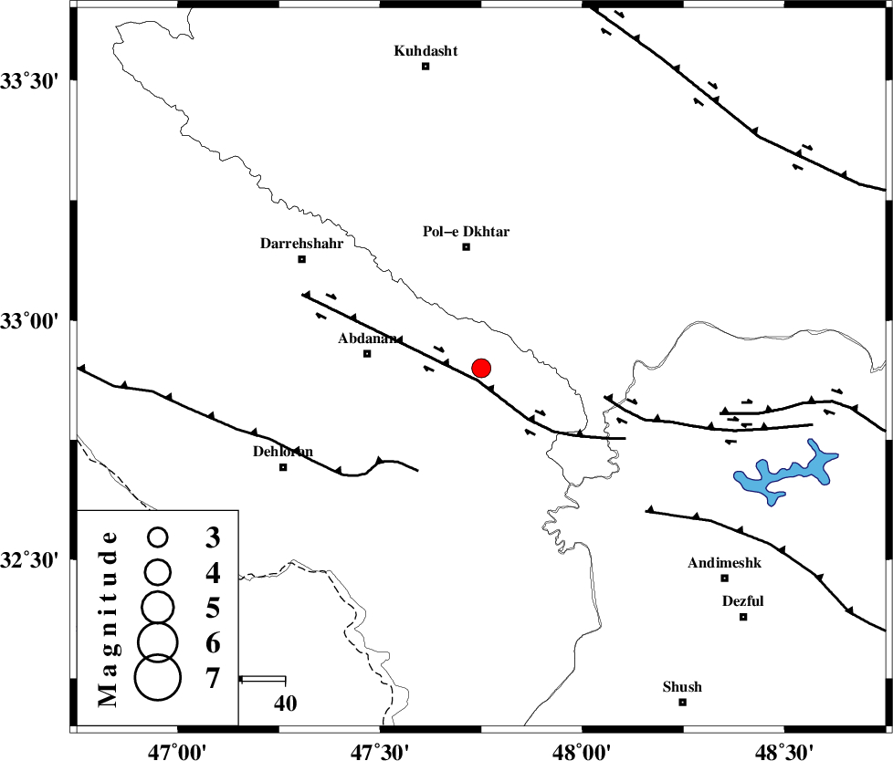
| Location | Lat:32.9 Lon: 47.75 |
| Region | Ilam Province, 28 km South of Pol-e dokhtar |
Nearest Cities |
|
| 17 km North East of Sarabbagh, Ilam Province | |
| 23 km South of Sarab hammam, Lorestan Province | |
| 27 km East of Abdanan, Ilam Province | |
| 28 km South of Pol-e dokhtar, Lorestan Province | |
| 38 km South of Morani, Lorestan Province | |
| Depth | 14 km |
| Agency | |
Faults within 150 km: |
|
| BALARUD_F_Z1 (Length: 87 km) , Distance to epicenter: 3 km | |
| MFF6 (Length: 144 km) , Distance to epicenter: 28 km | |
| BALARUD_F_Z3 (Length: 53 km) , Distance to epicenter: 29 km | |
| Number of Phases | 6 |
| RMS | 0.1 |
| Number of Stations | 6 |
| Error in Latitude | >17.6 km |
| Error in Longitude | 10.2 km |
| Error in Depth | 28.5 km |
Download waveform in seisan format
to download seisan software Click here
to access information about IIEES stations Click here
Amplitude | ||||||||
| UID | Agency | Station | Component | Amplitude | Period | Arrival Time | Proccessing Time | Signal Clip |
| 93148 | IIEES | AHRM | N | 7.6 | 0.32 | 2014-08-19 19:48:22 | 2014-08-19 10:38:00 | n |
Phase | ||||||||||||
| Agency | Station | Component | Phase Type | Phase Quality | First Motion | Observed Arrival Time | Time Residual | Loc. Flag | Input Weight | Distance | Azimuth | |
| IIEES | KHMZ | Z | Pn | E | 2014-08-19 19:46:51 | -0.07 | y | 226 | 65 | |||
| IIEES | SNGE | Z | Pn | E | 2014-08-19 19:46:54 | -0.04 | y | 246 | 351 | |||
| IIEES | ASAO | Z | Pn | E | 2014-08-19 19:46:58 | -0.01 | y | 279 | 48 | |||
| IIEES | ASAO | N | Sg | E | 2014-08-19 19:47:34 | -0.02 | y | 279 | 48 | |||
| IIEES | CHTH | Z | Pn | E | 2014-08-19 19:47:20 | 0.19 | y | 455 | 42 | |||
| IIEES | DAMV | Z | Pn | E | 2014-08-19 19:47:25 | 0.01 | y | 492 | 51 | |||