
Magnitude |
:3.3 |
| Date & Time (UTC) | 2014-08-19 02:18:24.2 |
| Date & Time (Local) | 1393/5/28 06:48:24.2 |
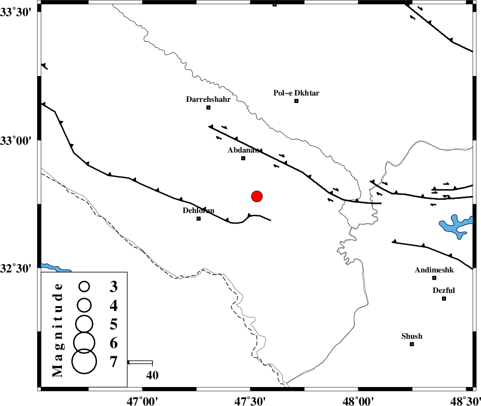
| Location | Lat:32.78 Lon: 47.53 |
| Region | Ilam Province, 17 km South of Abdanan |
Nearest Cities |
|
| 14 km South of Sarabbagh, Ilam Province | |
| 18 km South of Abdanan, Ilam Province | |
| 27 km North East of Dehloran, Ilam Province | |
| 31 km North East of Musian, Ilam Province | |
| 38 km South West of Sarab hammam, Lorestan Province | |
| Depth | 14 km |
| Agency | |
Faults within 150 km: |
|
| MFF6 (Length: 144 km) , Distance to epicenter: 8 km | |
| BALARUD_F_Z1 (Length: 87 km) , Distance to epicenter: 22 km | |
| BALARUD_F_Z3 (Length: 53 km) , Distance to epicenter: 49 km | |
| Number of Phases | 6 |
| RMS | 0.1 |
| Number of Stations | 4 |
| Error in Latitude | >1.6 km |
| Error in Longitude | 3.9 km |
| Error in Depth | 5.4 km |
Download waveform in seisan format
to download seisan software Click here
to access information about IIEES stations Click here
Amplitude | ||||||||
| UID | Agency | Station | Component | Amplitude | Period | Arrival Time | Proccessing Time | Signal Clip |
| 93093 | IIEES | SHGR | E | 593.5 | 0.52 | 2014-08-19 02:19:09 | 2014-08-19 03:40:00 | n |
Phase | ||||||||||||
| Agency | Station | Component | Phase Type | Phase Quality | First Motion | Observed Arrival Time | Time Residual | Loc. Flag | Input Weight | Distance | Azimuth | |
| IIEES | SHGR | Z | Pg | E | 2014-08-19 02:18:47 | -0.17 | y | 141 | 122 | |||
| IIEES | SHGR | N | Sg | E | 2014-08-19 02:19:04 | 0.14 | y | 141 | 122 | |||
| IIEES | KHMZ | Z | Pn | E | 2014-08-19 02:19:03 | -0.05 | y | 250 | 64 | |||
| IIEES | SNGE | Z | Pn | E | 2014-08-19 02:19:04 | 0.08 | y | 257 | 356 | |||
| IIEES | ASAO | Z | Pn | E | 2014-08-19 02:19:09 | 0.04 | y | 303 | 49 | |||
| IIEES | ASAO | E | Sg | E | 2014-08-19 02:19:49 | -0.03 | y | 303 | 49 | |||