
Magnitude |
:4.2 |
| Date & Time (UTC) | 2014-08-18 02:59:29.6 |
| Date & Time (Local) | 1393/5/27 07:29:29.6 |
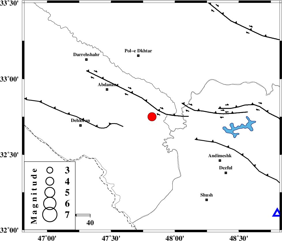
| Location | Lat:32.75 Lon: 47.82 |
| Region | Ilam Province, 46 km South-East of Pol-e dokhtar |
Nearest Cities |
|
| 29 km South East of Sarabbagh, Ilam Province | |
| 39 km South East of Abdanan, Ilam Province | |
| 39 km West of Bidruyeh, Khoozestan Province | |
| 41 km South East of Sarab hammam, Lorestan Province | |
| 41 km North West of Hoseinieh, Khoozestan Province | |
| Depth | 14 km |
| Agency | |
Faults within 150 km: |
|
| BALARUD_F_Z1 (Length: 87 km) , Distance to epicenter: 6 km | |
| MFF6 (Length: 144 km) , Distance to epicenter: 22 km | |
| BALARUD_F_Z3 (Length: 53 km) , Distance to epicenter: 24 km | |
| Number of Phases | 9 |
| RMS | 0.4 |
| Number of Stations | 7 |
| Error in Latitude | >2.7 km |
| Error in Longitude | 9.2 km |
| Error in Depth | 9.2 km |
Download waveform in seisan format
to download seisan software Click here
to access information about IIEES stations Click here
Amplitude | ||||||||
| UID | Agency | Station | Component | Amplitude | Period | Arrival Time | Proccessing Time | Signal Clip |
| 92981 | IIEES | SHGR | N | 5128.6 | 0.57 | 2014-08-18 03:00:13 | 2014-08-18 04:56:00 | n |
| 92982 | IIEES | SHGR | E | 5786.6 | 0.67 | 2014-08-18 03:00:13 | 2014-08-18 04:56:00 | n |
Phase | ||||||||||||
| Agency | Station | Component | Phase Type | Phase Quality | First Motion | Observed Arrival Time | Time Residual | Loc. Flag | Input Weight | Distance | Azimuth | |
| IIEES | SHGR | Z | Pg | E | 2014-08-18 02:59:48 | -0.61 | y | 116 | 127 | |||
| IIEES | SHGR | N | S | E | 2014-08-18 03:00:03 | 0.43 | y | 116 | 127 | |||
| IIEES | ASAO | Z | Pn | E | 2014-08-18 03:00:13 | 0.22 | y | 286 | 45 | |||
| IIEES | ASAO | E | Sg | E | 2014-08-18 03:00:50 | -0.17 | y | 286 | 45 | |||
| IIEES | CHTH | Z | P | E | 2014-08-18 03:00:35 | 0.4 | y | 464 | 40 | |||
| IIEES | AHRM | Z | Pn | E | 2014-08-18 03:00:44 | 0.01 | y | 544 | 141 | |||
| IIEES | GHIR | Z | Pn | E | 2014-08-18 03:01:04 | -0.09 | y | 700 | 134 | |||
| IIEES | TABS | Z | Pn | E | 2014-08-18 03:01:25 | -0.26 | y | 872 | 81 | |||
| IIEES | SHRT | Z | Pn | E | 2014-08-18 03:02:01 | -0.51 | y | 1166 | 82 | |||