
Magnitude |
:2.2 |
| Date & Time (UTC) | 2014-08-06 13:37:06.5 |
| Date & Time (Local) | 1393/5/15 18:07:06.5 |
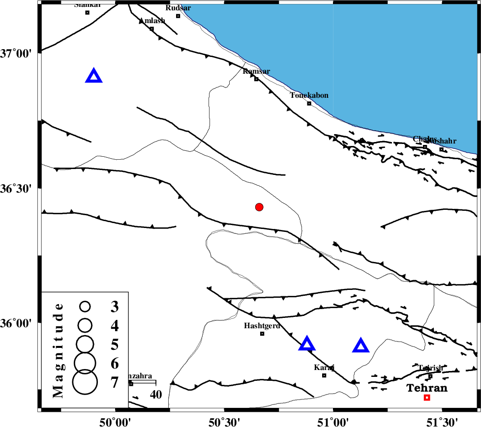
| Location | Lat:36.43 Lon: 50.66 |
| Region | Ghazvin Province, 52 km North of Hashtgerd |
Nearest Cities |
|
| 18 km East of Moallemkelayeh, Ghazvin Province | |
| 27 km North of Taleqan, Tehran Province | |
| 28 km North West of Shahrak, Tehran Province | |
| 32 km South East of Tamol, Mazandaran Province | |
| 35 km North East of Rajaeedasht, Ghazvin Province | |
| Depth | 15 km |
| Agency | |
Faults within 150 km: |
|
| ALAMUTRUD_F (Length: 140 km) , Distance to epicenter: 9 km | |
| BONAN_F (Length: 74 km) , Distance to epicenter: 14 km | |
| KANDOVAN_F (Length: 90 km) , Distance to epicenter: 32 km | |
| Number of Phases | 6 |
| RMS | 0.5 |
| Number of Stations | 5 |
| Error in Latitude | >4.7 km |
| Error in Longitude | 5.9 km |
| Error in Depth | 9.1 km |
Download waveform in seisan format
to download seisan software Click here
to access information about IIEES stations Click here
Amplitude | ||||||||
| UID | Agency | Station | Component | Amplitude | Period | Arrival Time | Proccessing Time | Signal Clip |
| 92910 | IIEES | ZNJK | E | 19.7 | 0.44 | 2014-08-06 13:38:06 | 2014-08-07 03:51:00 | n |
| 92911 | IIEES | ASAO | E | 19.1 | 0.44 | 2014-08-06 13:38:09 | 2014-08-07 03:51:00 | n |
| 92912 | IIEES | ASAO | N | 39.6 | 0.38 | 2014-08-06 13:38:09 | 2014-08-07 03:51:00 | n |
Phase | ||||||||||||
| Agency | Station | Component | Phase Type | Phase Quality | First Motion | Observed Arrival Time | Time Residual | Loc. Flag | Input Weight | Distance | Azimuth | |
| IIEES | CHTH | Z | Pg | E | 2014-08-06 13:37:18 | -0.99 | y | 71.1 | 144 | |||
| IIEES | DAMV | Z | Pg | E | 2014-08-06 13:37:31 | 0.69 | y | 147 | 126 | |||
| IIEES | ZNJK | Z | Pg | E | 2014-08-06 13:37:35 | -0.18 | y | 179 | 279 | |||
| IIEES | ASAO | Z | Pn | E | 2014-08-06 13:37:41 | 0.28 | y | 216 | 196 | |||
| IIEES | ASAO | N | Sg | E | 2014-08-06 13:38:08 | 0.11 | y | 216 | 196 | |||
| IIEES | GRMI | Z | Pn | E | 2014-08-06 13:37:59 | 0.09 | y | 360 | 318 | |||