
Magnitude |
:2.6 |
| Date & Time (UTC) | 2014-07-15 06:12:48.1 |
| Date & Time (Local) | 1393/4/24 10:42:48.1 |
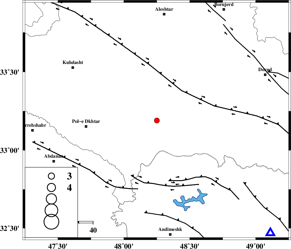
| Location | Lat:33.19 Lon: 48.25 |
| Region | Lorestan Province, 34 km South-West of Khorramabad |
Nearest Cities |
|
| 23 km South of Shoorab-e sofla, Lorestan Province | |
| 24 km South West of Daraei, Lorestan Province | |
| 31 km South West of Badrabad-e sofla, Lorestan Province | |
| 31 km South East of Godar-e mahmudvand, Lorestan Province | |
| 33 km South East of Maeulan, Lorestan Province | |
| Depth | 14 km |
| Agency | |
Faults within 150 km: |
|
| HZF4 (Length: 492 km) , Distance to epicenter: 28 km | |
| BALARUD_F_Z3 (Length: 53 km) , Distance to epicenter: 43 km | |
| BALARUD_F_Z2 (Length: 58 km) , Distance to epicenter: 44 km | |
| Number of Phases | 5 |
| RMS | 0.1 |
| Number of Stations | 5 |
| Error in Latitude | >2.1 km |
| Error in Longitude | 9.3 km |
| Error in Depth | 5.7 km |
Download waveform in seisan format
to download seisan software Click here
to access information about IIEES stations Click here
Amplitude | ||||||||
| UID | Agency | Station | Component | Amplitude | Period | Arrival Time | Proccessing Time | Signal Clip |
| 92802 | IIEES | SHGR | E | 128.4 | 0.3 | 2014-07-15 06:13:31 | 2014-07-15 07:54:00 | n |
| 92803 | IIEES | SHGR | N | 151.3 | 0.48 | 2014-07-15 06:13:33 | 2014-07-15 07:54:00 | n |
| 92804 | IIEES | ASAO | E | 34.1 | 0.52 | 2014-07-15 06:13:57 | 2014-07-15 07:54:00 | n |
| 92805 | IIEES | ASAO | N | 41.3 | 0.43 | 2014-07-15 06:14:06 | 2014-07-15 07:54:00 | n |
| 92806 | IIEES | SNGE | N | 43.4 | 0.7 | 2014-07-15 06:13:59 | 2014-07-15 07:54:00 | n |
Phase | ||||||||||||
| Agency | Station | Component | Phase Type | Phase Quality | First Motion | Observed Arrival Time | Time Residual | Loc. Flag | Input Weight | Distance | Azimuth | |
| IIEES | SHGR | Z | Pg | E | 2014-07-15 06:13:09 | -0.13 | y | 131 | 157 | |||
| IIEES | SHGR | N | Sg | E | 2014-07-15 06:13:26 | 0.09 | y | 131 | 157 | |||
| IIEES | KHMZ | Z | Pg | E | 2014-07-15 06:13:16 | -0.11 | y | 171 | 69 | |||
| IIEES | ASAO | Z | Pn | E | 2014-07-15 06:13:23 | 0.08 | y | 223 | 47 | |||
| IIEES | GHVR | Z | Pn | E | 2014-07-15 06:13:34 | 0.07 | y | 312 | 62 | |||