
Magnitude |
:3.1 |
| Date & Time (UTC) | 2014-07-13 15:29:05.4 |
| Date & Time (Local) | 1393/4/22 19:59:05.4 |
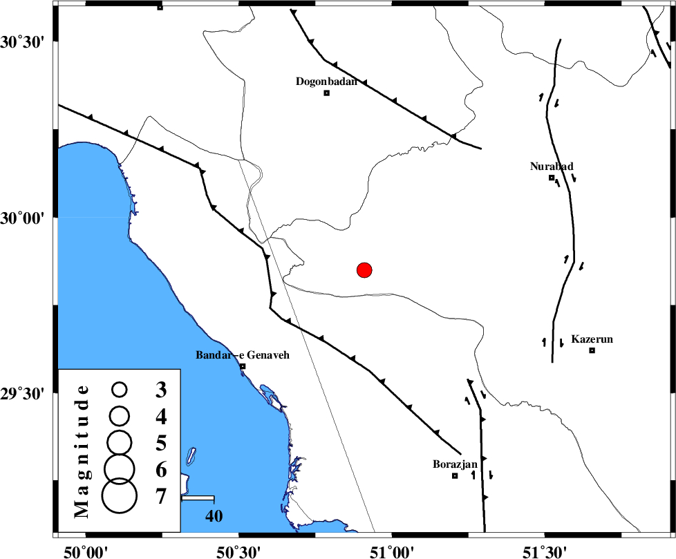
| Location | Lat:29.85 Lon: 50.91 |
| Region | Fars Province, 57 km South-East of Dogonbadan |
Nearest Cities |
|
| 36 km North East of Chehar rustaee, Bushehr Province | |
| 37 km North East of Mohammad salehi, Bushehr Province | |
| 37 km South West of Babamonir, Fars Province | |
| 43 km North of Dehkohneh, Bushehr Province | |
| 49 km North East of Bandar-e genaveh, Bushehr Province | |
| Depth | 45 km |
| Agency | |
Faults within 150 km: |
|
| ZFF3 (Length: 125 km) , Distance to epicenter: 26 km | |
| BORAZJAN_F (Length: 168 km) , Distance to epicenter: 47 km | |
| MISHAN_F (Length: 76 km) , Distance to epicenter: 51 km | |
| Number of Phases | 6 |
| RMS | 0 |
| Number of Stations | 4 |
| Error in Latitude | >2.9 km |
| Error in Longitude | 5 km |
| Error in Depth | 4.2 km |
Download waveform in seisan format
to download seisan software Click here
to access information about IIEES stations Click here
Amplitude | ||||||||
| UID | Agency | Station | Component | Amplitude | Period | Arrival Time | Proccessing Time | Signal Clip |
| 92796 | IIEES | GHIR | E | 86.3 | 0.44 | 2014-07-13 15:30:39 | 2014-07-13 06:13:00 | n |
Phase | ||||||||||||
| Agency | Station | Component | Phase Type | Phase Quality | First Motion | Observed Arrival Time | Time Residual | Loc. Flag | Input Weight | Distance | Azimuth | |
| IIEES | AHRM | Z | Pg | E | 2014-07-13 15:29:25 | 0.05 | y | 116 | 161 | |||
| IIEES | AHRM | Z | Sg | E | 2014-07-13 15:29:39 | -0.05 | y | 116 | 161 | |||
| IIEES | GHIR | Z | Pn | E | 2014-07-13 15:29:43 | 0.01 | y | 266 | 130 | |||
| IIEES | YZKH | Z | Pn | E | 2014-07-13 15:30:06 | 0 | y | 450 | 50 | |||
| IIEES | ASAO | Z | Pn | E | 2014-07-13 15:30:16 | 0.01 | y | 527 | 351 | |||
| IIEES | ASAO | N | Sn | 2014-07-13 15:31:07 | -0.03 | y | 527 | 351 | ||||