
Magnitude |
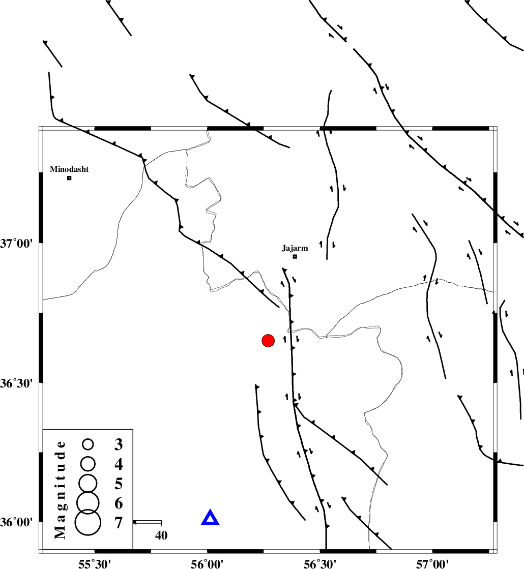
:3.5 |
| Date & Time (UTC) | 2014-07-02 05:38:12.7 |
| Date & Time (Local) | 1393/4/11 10:08:12.7 |
| Location | Lat:36.65 Lon: 56.27 |
| Region | Semnan Province, 35 km South-West of Jajarm |
Nearest Cities |
|
| 35 km South West of Jajarm, Khorasan(north) Province | |
| 38 km South of Garmeh, Khorasan(north) Province | |
| 46 km North West of Frumad, Semnan Province | |
| 52 km South West of Farashiyan, Khorasan(center) Province | |
| 61 km South East of Nardin, Semnan Province | |
| Depth | 14 km |
| Agency | |
Faults within 150 km: |
|
| JOGHATAI_F (Length: 70 km) , Distance to epicenter: 15 km | |
| MEYAMEY_F (Length: 141 km) , Distance to epicenter: 16 km | |
| JAJARAM_F (Length: 77 km) , Distance to epicenter: 21 km | |
| Number of Phases | 12 |
| RMS | 0.3 |
| Number of Stations | 10 |
| Error in Latitude | >1.7 km |
| Error in Longitude | 3.6 km |
| Error in Depth | 6.3 km |
Download waveform in seisan format
to download seisan software Click here
to access information about IIEES stations Click here
Amplitude | ||||||||
| UID | Agency | Station | Component | Amplitude | Period | Arrival Time | Proccessing Time | Signal Clip |
| 92719 | IIEES | YZKH | N | 42.9 | 0.07 | 2014-07-02 05:40:44 | 2014-07-02 07:17:00 | n |
Phase | ||||||||||||
| Agency | Station | Component | Phase Type | Phase Quality | First Motion | Observed Arrival Time | Time Residual | Loc. Flag | Input Weight | Distance | Azimuth | |
| IIEES | BJRD | Z | Pg | E | 2014-07-02 05:38:37 | -0.31 | y | 154 | 41 | |||
| IIEES | BJRD | E | Sg | E | 2014-07-02 05:38:57 | 0.14 | y | 154 | 41 | |||
| IIEES | TABS | Z | Pn | E | 2014-07-02 05:39:03 | 0.19 | y | 342 | 167 | |||
| IIEES | TABS | E | Sg | E | 2014-07-02 05:39:48 | -0.16 | y | 342 | 167 | |||
| IIEES | CHTH | Z | Pn | E | 2014-07-02 05:39:19 | 0.26 | y | 470 | 261 | |||
| IIEES | SHRT | Z | Pn | E | 2014-07-02 05:39:21 | -0.02 | y | 495 | 131 | |||
| IIEES | YZKH | Z | Pn | E | 2014-07-02 05:39:21 | -0.37 | y | 497 | 199 | |||
| IIEES | GHVR | Z | Pn | E | 2014-07-02 05:39:24 | -0.22 | y | 515 | 244 | |||
| IIEES | BSRN | Z | Pn | E | 2014-07-02 05:39:33 | 0.21 | y | 582 | 152 | |||
| IIEES | ASAO | Z | Pn | E | 2014-07-02 05:39:36 | -0.02 | y | 612 | 249 | |||
| IIEES | KRBR | Z | Pn | E | 2014-07-02 05:39:53 | 0.63 | y | 741 | 176 | |||
| IIEES | GRMI | Z | Pn | E | 2014-07-02 05:39:56 | 0.02 | y | 776 | 290 | |||