
Magnitude |
:3.9 |
| Date & Time (UTC) | 2014-06-29 01:09:29.3 |
| Date & Time (Local) | 1393/4/8 05:39:29.3 |
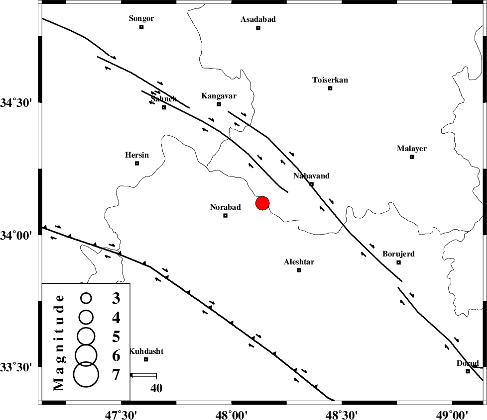
| Location | Lat:34.12 Lon: 48.14 |
| Region | Lorestan Province, 17 km East of Nurabad |
Nearest Cities |
|
| 9 km North of Kafraj, Lorestan Province | |
| 11 km West of Gian, Hamedan Province | |
| 14 km East of Froozvand-e vosta, Lorestan Province | |
| 16 km South West of Barzul, Hamedan Province | |
| 16 km North East of Nurabad, Lorestan Province | |
| Depth | 18 km |
| Agency | |
Faults within 150 km: |
|
| SAHANEH_F (Length: 77 km) , Distance to epicenter: 10 km | |
| NAHAVAND_F (Length: 102 km) , Distance to epicenter: 21 km | |
| HZF4 (Length: 492 km) , Distance to epicenter: 50 km | |
| Number of Phases | 5 |
| RMS | 0.1 |
| Number of Stations | 4 |
| Error in Latitude | >2.8 km |
| Error in Longitude | 7.6 km |
| Error in Depth | 4.3 km |
Download waveform in seisan format
to download seisan software Click here
to access information about IIEES stations Click here
Amplitude | ||||||||
| UID | Agency | Station | Component | Amplitude | Period | Arrival Time | Proccessing Time | Signal Clip |
| 92692 | IIEES | ASAO | N | 1451.5 | 0.56 | 2014-06-29 01:10:31 | 2014-06-29 02:53:00 | n |
Phase | ||||||||||||
| Agency | Station | Component | Phase Type | Phase Quality | First Motion | Observed Arrival Time | Time Residual | Loc. Flag | Input Weight | Distance | Azimuth | |
| IIEES | KHMZ | Z | Pg | E | 2014-06-29 01:09:58 | -0.03 | y | 174 | 104 | |||
| IIEES | ASAO | Z | Pg | E | 2014-06-29 01:09:59 | 0.1 | y | 180 | 74 | |||
| IIEES | GHVR | Z | Pn | E | 2014-06-29 01:10:12 | -0.03 | y | 288 | 81 | |||
| IIEES | CHTH | Z | Pg | E | 2014-06-29 01:10:24 | -0.02 | y | 337 | 53 | |||
| IIEES | CHTH | N | Sg | E | 2014-06-29 01:11:04 | -0.02 | y | 337 | 53 | |||