
Magnitude |
:3.5 |
| Date & Time (UTC) | 2014-06-25 14:20:11.1 |
| Date & Time (Local) | 1393/4/4 18:50:11.1 |
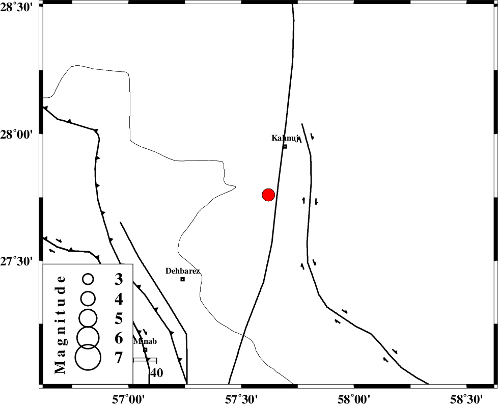
| Location | Lat:27.76 Lon: 57.62 |
| Region | Kerman Province, 22 km South of Kahnuj |
Nearest Cities |
|
| 14 km North of Bargah, Kerman Province | |
| 22 km South of Kahnuj, Kerman Province | |
| 24 km North East of Bejogan, Kerman Province | |
| 30 km North East of Nodezh, Kerman Province | |
| 34 km East of Fariab, Hormozgan Province | |
| Depth | 14 km |
| Agency | |
Faults within 150 km: |
|
| SABZEVARAN_F (Length: 190 km) , Distance to epicenter: 7 km | |
| JIROFT_F (Length: 144 km) , Distance to epicenter: 19 km | |
| ZENDAN_MINAB_F_Z1 (Length: 183 km) , Distance to epicenter: 63 km | |
| Number of Phases | 5 |
| RMS | 0.1 |
| Number of Stations | 3 |
| Error in Latitude | >3.1 km |
| Error in Longitude | 7.1 km |
| Error in Depth | 8.5 km |
Download waveform in seisan format
to download seisan software Click here
to access information about IIEES stations Click here
Amplitude | ||||||||
| UID | Agency | Station | Component | Amplitude | Period | Arrival Time | Proccessing Time | Signal Clip |
| 92679 | IIEES | KRBR | N | 268 | 0.4 | 2014-06-25 14:21:26 | 2014-06-25 04:11:00 | n |
Phase | ||||||||||||
| Agency | Station | Component | Phase Type | Phase Quality | First Motion | Observed Arrival Time | Time Residual | Loc. Flag | Input Weight | Distance | Azimuth | |
| IIEES | BNDS | Z | Pg | E | 2014-06-25 14:20:35 | -0.23 | y | 148 | 255 | |||
| IIEES | BNDS | N | Sg | E | 2014-06-25 14:20:54 | 0.16 | y | 148 | 255 | |||
| IIEES | KRBR | Z | Pn | E | 2014-06-25 14:20:51 | 0.07 | y | 260 | 341 | |||
| IIEES | KRBR | E | Sg | E | 2014-06-25 14:21:24 | -0.05 | y | 260 | 341 | |||
| IIEES | TABS | Z | Pn | E | 2014-06-25 14:21:40 | 0.09 | y | 655 | 356 | |||