
Magnitude |
:2.8 |
| Date & Time (UTC) | 2014-06-24 23:50:02.0 |
| Date & Time (Local) | 1393/4/4 04:20:02.0 |
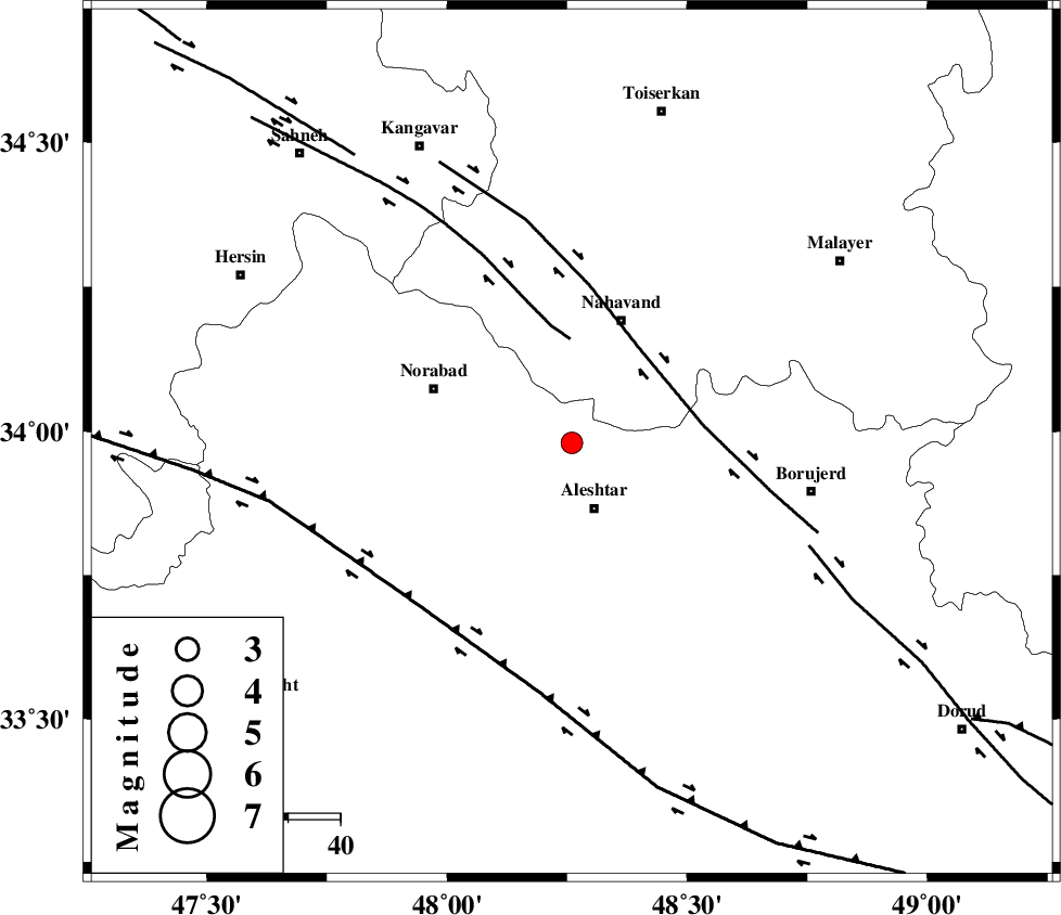
| Location | Lat:33.98 Lon: 48.26 |
| Region | Lorestan Province, 13 km North of Aleshtar |
Nearest Cities |
|
| 12 km North of Dehrahim, Lorestan Province | |
| 13 km North of Aleshtar, Lorestan Province | |
| 14 km North East of Firuz Abad, Lorestan Province | |
| 20 km North of Siyahpush, Lorestan Province | |
| 22 km West of Babaqasem, Hamedan Province | |
| Depth | 17 km |
| Agency | |
Faults within 150 km: |
|
| SAHANEH_F (Length: 77 km) , Distance to epicenter: 20 km | |
| NAHAVAND_F (Length: 102 km) , Distance to epicenter: 22 km | |
| HZF4 (Length: 492 km) , Distance to epicenter: 44 km | |
| Number of Phases | 5 |
| RMS | 0 |
| Number of Stations | 5 |
| Error in Latitude | >2.3 km |
| Error in Longitude | 2 km |
| Error in Depth | 3.6 km |
Download waveform in seisan format
to download seisan software Click here
to access information about IIEES stations Click here
Amplitude | ||||||||
| UID | Agency | Station | Component | Amplitude | Period | Arrival Time | Proccessing Time | Signal Clip |
| 92669 | IIEES | SNGE | N | 144.4 | 0.48 | 2014-06-24 23:50:51 | 2014-06-25 01:28:00 | n |
| 92670 | IIEES | SHGR | N | 83.3 | 0.4 | 2014-06-24 23:51:14 | 2014-06-25 01:28:00 | n |
| 92671 | IIEES | SHGR | E | 86.5 | 0.64 | 2014-06-24 23:51:18 | 2014-06-25 01:28:00 | n |
| 92672 | IIEES | GHVR | E | 45.2 | 0.52 | 2014-06-24 23:51:28 | 2014-06-25 01:28:00 | n |
Phase | ||||||||||||
| Agency | Station | Component | Phase Type | Phase Quality | First Motion | Observed Arrival Time | Time Residual | Loc. Flag | Input Weight | Distance | Azimuth | |
| IIEES | SNGE | Z | Pg | E | 2014-06-24 23:50:26 | -0.01 | y | 149 | 326 | |||
| IIEES | KHMZ | Z | Pg | E | 2014-06-24 23:50:28 | -0.03 | y | 160 | 99 | |||
| IIEES | ASAO | Z | Pg | E | 2014-06-24 23:50:30 | 0.03 | y | 174 | 68 | |||
| IIEES | SHGR | Z | Pn | E | 2014-06-24 23:50:35 | 0.01 | y | 213 | 166 | |||
| IIEES | GHVR | Z | Pn | E | 2014-06-24 23:50:44 | -0.01 | y | 280 | 78 | |||