
Magnitude |
:3.5 |
| Date & Time (UTC) | 2014-06-21 03:11:07.2 |
| Date & Time (Local) | 1393/3/31 07:41:07.2 |
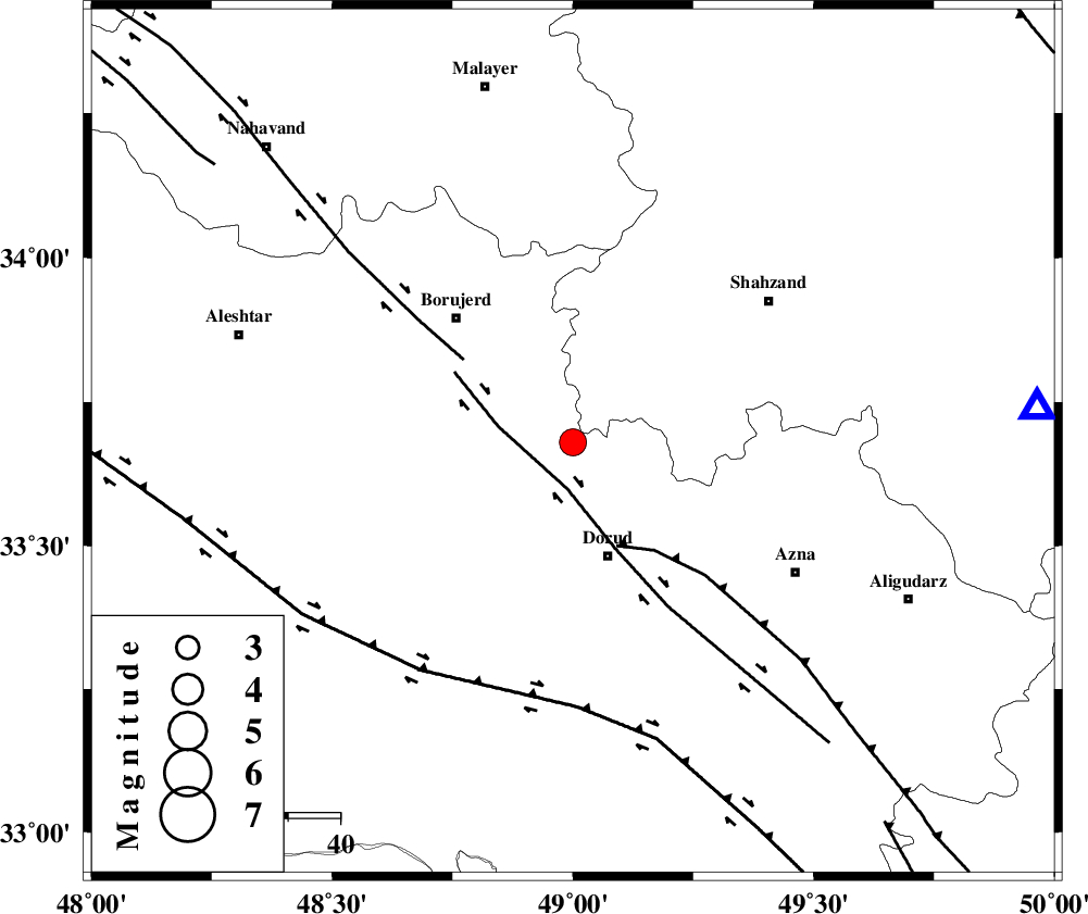
| Location | Lat:33.68 Lon: 49 |
| Region | Lorestan Province, 23 km North of Dorud |
Nearest Cities |
|
| 9 km North of Kagheh, Lorestan Province | |
| 11 km North East of Chalanchulan, Lorestan Province | |
| 13 km South of Hashian, Markazi Province | |
| 17 km North East of Razan, Lorestan Province | |
| 17 km North of Void, Lorestan Province | |
| Depth | 14 km |
| Agency | |
Faults within 150 km: |
|
| DORUD (Length: 100 km) , Distance to epicenter: 8 km | |
| MAIN_ZAGROS_R_F (Length: 1106 km) , Distance to epicenter: 22 km | |
| NAHAVAND_F (Length: 102 km) , Distance to epicenter: 26 km | |
| Number of Phases | 7 |
| RMS | 0.4 |
| Number of Stations | 5 |
| Error in Latitude | >5.2 km |
| Error in Longitude | 8.5 km |
| Error in Depth | 7.7 km |
Download waveform in seisan format
to download seisan software Click here
to access information about IIEES stations Click here
Amplitude | ||||||||
| UID | Agency | Station | Component | Amplitude | Period | Arrival Time | Proccessing Time | Signal Clip |
| 92656 | IIEES | SHGR | N | 756.6 | 0.34 | 2014-06-21 03:12:02 | 2014-06-21 04:58:00 | n |
| 92657 | IIEES | SHGR | E | 464.1 | 0.34 | 2014-06-21 03:12:03 | 2014-06-21 04:58:00 | n |
Phase | ||||||||||||
| Agency | Station | Component | Phase Type | Phase Quality | First Motion | Observed Arrival Time | Time Residual | Loc. Flag | Input Weight | Distance | Azimuth | |
| IIEES | ASAO | Z | Pg | E | 2014-06-21 03:11:29 | 0.01 | y | 135 | 44 | |||
| IIEES | ASAO | N | Sg | E | 2014-06-21 03:11:45 | -0.51 | y | 135 | 44 | |||
| IIEES | SHGR | Z | Pg | E | 2014-06-21 03:11:35 | -0.15 | y | 175 | 186 | |||
| IIEES | GHVR | Z | Pn | E | 2014-06-21 03:11:42 | -0.3 | y | 225 | 66 | |||
| IIEES | GHVR | E | Sg | E | 2014-06-21 03:12:11 | 0.3 | y | 225 | 66 | |||
| IIEES | CHTH | Z | Pn | E | 2014-06-21 03:11:54 | 0.65 | y | 314 | 38 | |||
| IIEES | YZKH | Z | Pn | E | 2014-06-21 03:12:22 | 0.11 | y | 542 | 104 | |||