
Magnitude |
:2.5 |
| Date & Time (UTC) | 2014-06-19 07:18:40.7 |
| Date & Time (Local) | 1393/3/29 11:48:40.7 |
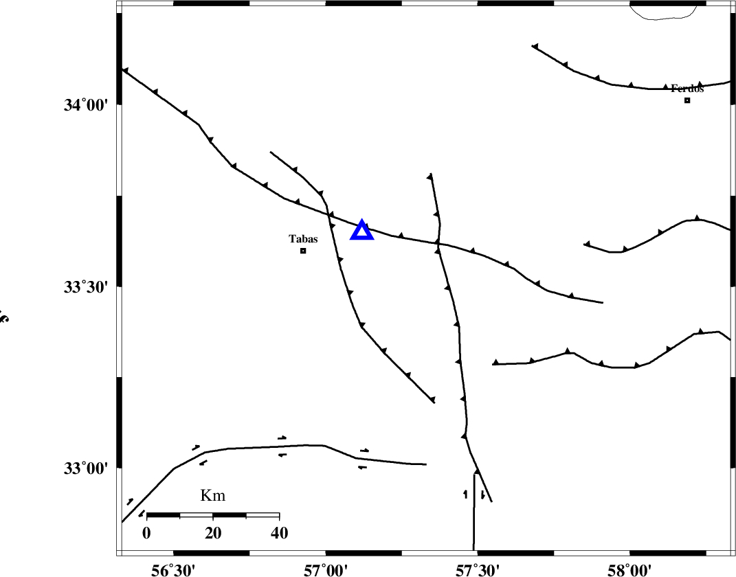
| Location | Lat:33.52 Lon: 57.33 |
| Region | Khorasan(center) Province, 39 km East of Tabas |
Nearest Cities |
|
| 20 km South of Arsak, Khorasan(center) Province | |
| 29 km North West of Dihuk, Yazd Province | |
| 34 km South of Reqqeh, Khorasan(center) Province | |
| 38 km North East of Kerit, Yazd Province | |
| 38 km East of Tabas, Yazd Province | |
| Depth | 14 km |
| Agency | |
Faults within 150 km: |
|
| ESFARDIAR_F (Length: 94 km) , Distance to epicenter: 10 km | |
| TABAS_F1 (Length: 91 km) , Distance to epicenter: 24 km | |
| TABAS_F2 (Length: 67 km) , Distance to epicenter: 33 km | |
| Number of Phases | 5 |
| RMS | 0.3 |
| Number of Stations | 4 |
| Error in Latitude | >8.1 km |
| Error in Longitude | 6.8 km |
| Error in Depth | 6.7 km |
Download waveform in seisan format
to download seisan software Click here
to access information about IIEES stations Click here
Amplitude | ||||||||
| UID | Agency | Station | Component | Amplitude | Period | Arrival Time | Proccessing Time | Signal Clip |
| 92648 | IIEES | YZKH | E | 19.2 | 0.47 | 2014-06-19 07:20:02 | 2014-06-19 09:17:00 | n |
| 92649 | IIEES | KRBR | E | 10.2 | 0.34 | 2014-06-19 07:20:32 | 2014-06-19 09:17:00 | n |
Phase | ||||||||||||
| Agency | Station | Component | Phase Type | Phase Quality | First Motion | Observed Arrival Time | Time Residual | Loc. Flag | Input Weight | Distance | Azimuth | |
| IIEES | TABS | Z | Pg | E | 2014-06-19 07:18:45 | -0.19 | y | 24.4 | 306 | |||
| IIEES | BSRN | Z | Pn | E | 2014-06-19 07:19:18 | 0.32 | y | 241 | 135 | |||
| IIEES | BSRN | N | Sg | E | 2014-06-19 07:19:48 | -0.13 | y | 241 | 135 | |||
| IIEES | YZKH | Z | Pn | E | 2014-06-19 07:19:24 | 0.28 | y | 285 | 245 | |||
| IIEES | KRBR | Z | P | E | 2014-06-19 07:19:37 | -0.33 | y | 396 | 188 | |||