
Magnitude |
:3 |
| Date & Time (UTC) | 2014-06-17 13:43:14.7 |
| Date & Time (Local) | 1393/3/27 18:13:14.7 |
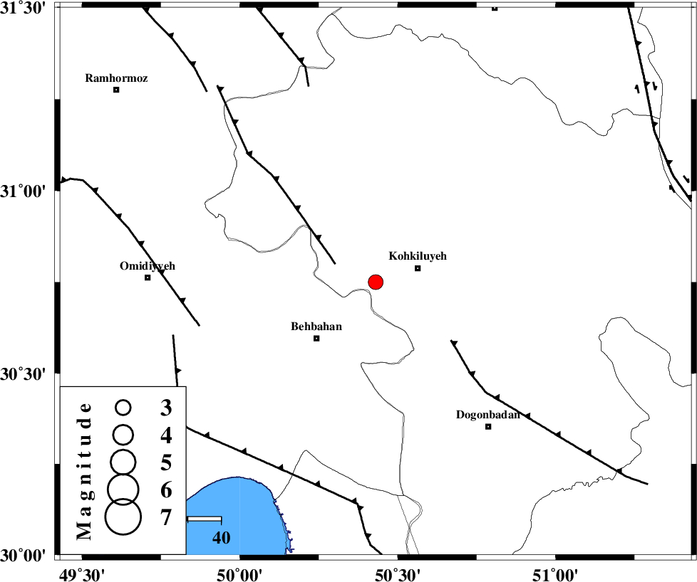
| Location | Lat:30.75 Lon: 50.43 |
| Region | Kohkiluieh va boyerahmad Province, 14 km West of Dehdasht |
Nearest Cities |
|
| 13 km West of Dehdasht, Kohkiluieh va boyerahmad Province | |
| 18 km North East of Mansuriyeh, Khoozestan Province | |
| 24 km North East of Dodange-ye bozorg, Khoozestan Province | |
| 25 km North East of Behbahan, Khoozestan Province | |
| 25 km South of Lendeh, Kohkiluieh va boyerahmad Province | |
| Depth | 14 km |
| Agency | |
Faults within 150 km: |
|
| MFF4 (Length: 62 km) , Distance to epicenter: 13 km | |
| MISHAN_F (Length: 76 km) , Distance to epicenter: 29 km | |
| AGHAJARI_F (Length: 88 km) , Distance to epicenter: 55 km | |
| Number of Phases | 4 |
| RMS | 0.1 |
| Number of Stations | 3 |
| Error in Latitude | >2.9 km |
| Error in Longitude | 5.8 km |
| Error in Depth | 14.1 km |
Download waveform in seisan format
to download seisan software Click here
to access information about IIEES stations Click here
Amplitude | ||||||||
| UID | Agency | Station | Component | Amplitude | Period | Arrival Time | Proccessing Time | Signal Clip |
| 92639 | IIEES | SHGR | N | 126.7 | 0.4 | 2014-06-17 13:44:20 | 2014-06-17 03:03:00 | n |
| 92640 | IIEES | SHGR | E | 124.9 | 0.4 | 2014-06-17 13:44:25 | 2014-06-17 03:03:00 | n |
Phase | ||||||||||||
| Agency | Station | Component | Phase Type | Phase Quality | First Motion | Observed Arrival Time | Time Residual | Loc. Flag | Input Weight | Distance | Azimuth | |
| IIEES | SHGR | Z | Pg | E | 2014-06-17 13:43:49 | -0.08 | y | 216 | 315 | |||
| IIEES | SHGR | N | Sg | E | 2014-06-17 13:44:15 | 0.06 | y | 216 | 315 | |||
| IIEES | AHRM | Z | Pn | E | 2014-06-17 13:43:50 | 0.02 | y | 225 | 158 | |||
| IIEES | YZKH | Z | Pn | E | 2014-06-17 13:44:16 | 0 | y | 435 | 64 | |||