
Magnitude |
:2.3 |
| Date & Time (UTC) | 2014-06-14 12:53:46.3 |
| Date & Time (Local) | 1393/3/24 17:23:46.3 |
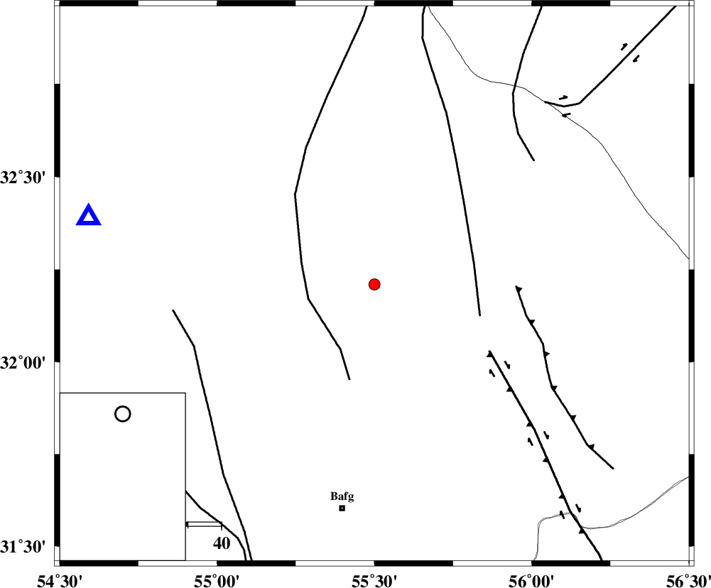
| Location | Lat:32.21 Lon: 55.5 |
| Region | Yazd Province, 68 km North-East of Bafq |
Nearest Cities |
|
| 59 km North West of Kushk, Yazd Province | |
| 62 km North West of Behabad, Yazd Province | |
| 65 km North of Mobarake, Yazd Province | |
| 68 km North East of Bafq, Yazd Province | |
| 76 km North West of Benestan, Yazd Province | |
| Depth | 15 km |
| Agency | |
Faults within 150 km: |
|
| POSHT_E_BADAM_F (Length: 128 km) , Distance to epicenter: 20 km | |
| SARBALA_F (Length: 92 km) , Distance to epicenter: 30 km | |
| KUHBANAN_F (Length: 189 km) , Distance to epicenter: 40 km | |
| Number of Phases | 3 |
| RMS | 0 |
| Number of Stations | 3 |
| Error in Latitude | >1.8 km |
| Error in Longitude | 1.8 km |
| Error in Depth | 0 km |
Download waveform in seisan format
to download seisan software Click here
to access information about IIEES stations Click here
Amplitude | ||||||||
| UID | Agency | Station | Component | Amplitude | Period | Arrival Time | Proccessing Time | Signal Clip |
| 92596 | IIEES | TABS | N | 11.4 | 0.44 | 2014-06-14 12:54:58 | 2014-06-14 04:30:00 | n |
| 92597 | IIEES | KRBR | E | 20.2 | 0.48 | 2014-06-14 12:55:06 | 2014-06-14 04:30:00 | n |
| 92598 | IIEES | KRBR | N | 17.8 | 0.48 | 2014-06-14 12:55:08 | 2014-06-14 04:30:00 | n |
Phase | ||||||||||||
| Agency | Station | Component | Phase Type | Phase Quality | First Motion | Observed Arrival Time | Time Residual | Loc. Flag | Input Weight | Distance | Azimuth | |
| IIEES | YZKH | Z | Pg | E | 2014-06-14 12:54:01 | 0 | y | 88.1 | 283 | |||
| IIEES | TABS | Z | Pg | E | 2014-06-14 12:54:22 | 0 | y | 220 | 43 | |||
| IIEES | KRBR | Z | Pn | E | 2014-06-14 12:54:28 | 0 | y | 275 | 154 | |||