
Magnitude |
:2.7 |
| Date & Time (UTC) | 2014-06-14 09:18:28.4 |
| Date & Time (Local) | 1393/3/24 13:48:28.4 |
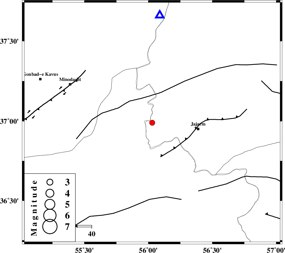
| Location | Lat:36.99 Lon: 56.03 |
| Region | Khorasan(north) Province, 32 km West of Jajarm |
Nearest Cities |
|
| 22 km East of Nardin, Semnan Province | |
| 23 km North West of Garmeh, Khorasan(north) Province | |
| 32 km North West of Jajarm, Khorasan(north) Province | |
| 32 km South East of Rezvan, Semnan Province | |
| 35 km East of Qaleh qafeh, Semnan Province | |
| Depth | 14 km |
| Agency | |
Faults within 150 km: |
|
| ROBATE_QARABIL_F (Length: 168 km) , Distance to epicenter: 18 km | |
| JAJARAM_F (Length: 77 km) , Distance to epicenter: 24 km | |
| MEYAMEY_F (Length: 141 km) , Distance to epicenter: 53 km | |
| Number of Phases | 6 |
| RMS | 0.2 |
| Number of Stations | 5 |
| Error in Latitude | >5.8 km |
| Error in Longitude | 8.6 km |
| Error in Depth | 7.7 km |
Download waveform in seisan format
to download seisan software Click here
to access information about IIEES stations Click here
Amplitude | ||||||||
| UID | Agency | Station | Component | Amplitude | Period | Arrival Time | Proccessing Time | Signal Clip |
| 92595 | IIEES | YZKH | E | 5.3 | 0.25 | 2014-06-14 09:20:38 | 2014-06-14 10:53:00 | n |
Phase | ||||||||||||
| Agency | Station | Component | Phase Type | Phase Quality | First Motion | Observed Arrival Time | Time Residual | Loc. Flag | Input Weight | Distance | Azimuth | |
| IIEES | SHRO | Z | Pg | E | 2014-06-14 09:18:46 | -0.15 | y | 109 | 181 | |||
| IIEES | SHRO | E | Sg | E | 2014-06-14 09:19:00 | 0.03 | y | 109 | 181 | |||
| IIEES | TABS | Z | Pn | E | 2014-06-14 09:19:23 | 0 | y | 384 | 165 | |||
| IIEES | YZKH | Z | Pn | E | 2014-06-14 09:19:41 | 0.05 | y | 527 | 195 | |||
| IIEES | SHRT | Z | Pn | E | 2014-06-14 09:19:42 | -0.21 | y | 536 | 133 | |||
| IIEES | BSRN | Z | Pn | E | 2014-06-14 09:19:54 | 0.41 | y | 626 | 152 | |||