
Magnitude |
:3.6 |
| Date & Time (UTC) | 2014-06-06 12:54:29.6 |
| Date & Time (Local) | 1393/3/16 17:24:29.6 |
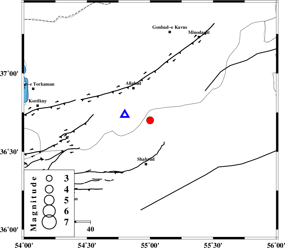
| Location | Lat:36.7 Lon: 55 |
| Region | Semnan Province, 31 km North of Shahrud |
Nearest Cities |
|
| 12 km North West of Qaleh-ye nokharqan, Semnan Province | |
| 24 km North of Bastam, Semnan Province | |
| 26 km South East of Ali Abad, Golestan Province | |
| 28 km North West of Kalateh khanj, Semnan Province | |
| 31 km North of Shahrud, Semnan Province | |
| Depth | 17 km |
| Agency | |
Faults within 150 km: |
|
| SHAVAR_F (Length: 87 km) , Distance to epicenter: 7 km | |
| KHAZAR_F (Length: 523 km) , Distance to epicenter: 34 km | |
| ASTANEH_F (Length: 72 km) , Distance to epicenter: 43 km | |
| Number of Phases | 4 |
| RMS | 0 |
| Number of Stations | 4 |
| Error in Latitude | >3.6 km |
| Error in Longitude | 5 km |
| Error in Depth | 6.9 km |
Download waveform in seisan format
to download seisan software Click here
to access information about IIEES stations Click here
Amplitude | ||||||||
| UID | Agency | Station | Component | Amplitude | Period | Arrival Time | Proccessing Time | Signal Clip |
| 92558 | IIEES | TABS | N | 131.5 | 0.56 | 2014-06-06 12:56:27 | 2014-06-06 02:16:00 | n |
| 92559 | IIEES | GHVR | E | 107.6 | 0.52 | 2014-06-06 12:56:34 | 2014-06-06 02:16:00 | n |
Phase | ||||||||||||
| Agency | Station | Component | Phase Type | Phase Quality | First Motion | Observed Arrival Time | Time Residual | Loc. Flag | Input Weight | Distance | Azimuth | |
| IIEES | SHRO | Z | Pg | E | 2014-06-06 12:54:49 | 0 | y | 119 | 130 | |||
| IIEES | BJRD | Z | Pn | E | 2014-06-06 12:55:07 | 0 | y | 241 | 62 | |||
| IIEES | BJRD | E | Sg | E | 2014-06-06 12:55:37 | 0 | y | 241 | 62 | |||
| IIEES | GHVR | Z | Pn | E | 2014-06-06 12:55:29 | 0.01 | y | 420 | 235 | |||