
Magnitude |
:3.4 |
| Date & Time (UTC) | 2014-06-01 17:34:09.6 |
| Date & Time (Local) | 1393/3/11 22:04:09.6 |
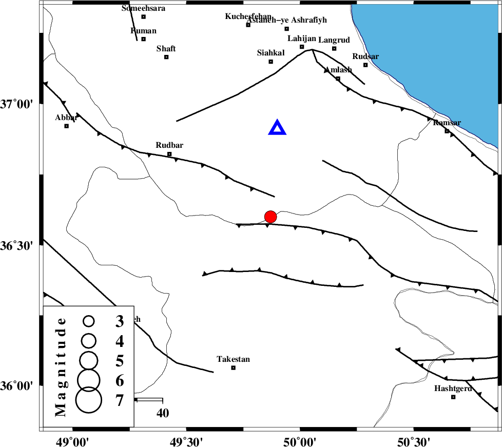
| Location | Lat:36.6 Lon: 49.87 |
| Region | Gilan Province, 39 km North-West of Qazvin |
Nearest Cities |
|
| 13 km South of Jirhandeh, Gilan Province | |
| 17 km South West of Kelishom, Gilan Province | |
| 29 km South of Barresar, Gilan Province | |
| 30 km North East of Kuhgir-e sofla, Ghazvin Province | |
| 31 km North East of Aqababa, Ghazvin Province | |
| Depth | 6 km |
| Agency | |
Faults within 150 km: |
|
| ALAMUTRUD_F (Length: 140 km) , Distance to epicenter: 3 km | |
| RUDBAR_F (Length: 93 km) , Distance to epicenter: 8 km | |
| N_QAZVIN_F (Length: 72 km) , Distance to epicenter: 22 km | |
| Number of Phases | 5 |
| RMS | 0.1 |
| Number of Stations | 5 |
| Error in Latitude | >2.6 km |
| Error in Longitude | 2.5 km |
| Error in Depth | 3.2 km |
Download waveform in seisan format
to download seisan software Click here
to access information about IIEES stations Click here
Amplitude | ||||||||
| UID | Agency | Station | Component | Amplitude | Period | Arrival Time | Proccessing Time | Signal Clip |
| 92538 | IIEES | GRMI | E | 140.6 | 0.48 | 2014-06-01 17:35:36 | 2014-06-01 07:01:00 | n |
| 92539 | IIEES | GRMI | N | 130.6 | 0.48 | 2014-06-01 17:35:36 | 2014-06-01 07:01:00 | n |
Phase | ||||||||||||
| Agency | Station | Component | Phase Type | Phase Quality | First Motion | Observed Arrival Time | Time Residual | Loc. Flag | Input Weight | Distance | Azimuth | |
| IIEES | ZNJK | Z | Pg | E | 2014-06-01 17:34:28 | -0.12 | y | 106 | 275 | |||
| IIEES | CHTH | Z | Pg | E | 2014-06-01 17:34:33 | -0.09 | y | 137 | 124 | |||
| IIEES | SNGE | Z | Pn | E | 2014-06-01 17:34:53 | 0.02 | y | 283 | 234 | |||
| IIEES | GRMI | Z | Pn | E | 2014-06-01 17:34:55 | 0.08 | y | 301 | 325 | |||
| IIEES | KHMZ | Z | Pn | E | 2014-06-01 17:34:57 | 0.13 | y | 317 | 178 | |||