
Magnitude |
:3.3 |
| Date & Time (UTC) | 2014-05-23 05:26:48.4 |
| Date & Time (Local) | 1393/3/2 09:56:48.4 |
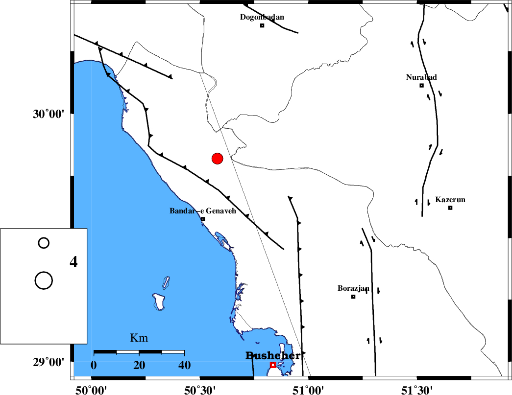
| Location | Lat:29.69 Lon: 50.92 |
| Region | Bushehr Province, 42 km North-East of Bandar-e genaveh |
Nearest Cities |
|
| 21 km North East of Chehar rustaee, Bushehr Province | |
| 25 km North of Dehkohneh, Bushehr Province | |
| 30 km North East of Mohammad salehi, Bushehr Province | |
| 36 km North East of Bandarehrig, Bushehr Province | |
| 40 km North West of Saedabad, Bushehr Province | |
| Depth | 14 km |
| Agency | |
Faults within 150 km: |
|
| ZFF3 (Length: 125 km) , Distance to epicenter: 14 km | |
| BORAZJAN_F (Length: 168 km) , Distance to epicenter: 36 km | |
| KAZERUN_F (Length: 96 km) , Distance to epicenter: 59 km | |
| Number of Phases | 6 |
| RMS | 0.1 |
| Number of Stations | 4 |
| Error in Latitude | >4.3 km |
| Error in Longitude | 6.1 km |
| Error in Depth | 10.8 km |
Download waveform in seisan format
to download seisan software Click here
to access information about IIEES stations Click here
Amplitude | ||||||||
| UID | Agency | Station | Component | Amplitude | Period | Arrival Time | Proccessing Time | Signal Clip |
| 92494 | IIEES | AHRM | E | 894.8 | 0.56 | 2014-05-23 05:27:19 | 2014-05-23 04:23:00 | n |
| 92495 | IIEES | AHRM | N | 1067.3 | 0.48 | 2014-05-23 05:27:22 | 2014-05-23 04:23:00 | n |
Phase | ||||||||||||
| Agency | Station | Component | Phase Type | Phase Quality | First Motion | Observed Arrival Time | Time Residual | Loc. Flag | Input Weight | Distance | Azimuth | |
| IIEES | AHRM | Z | Pg | E | 2014-05-23 05:27:05 | 0.11 | y | 98.7 | 158 | |||
| IIEES | AHRM | N | Sg | E | 2014-05-23 05:27:17 | -0.04 | y | 98.7 | 158 | |||
| IIEES | KHMZ | Z | Pn | E | 2014-05-23 05:27:52 | -0.18 | y | 458 | 349 | |||
| IIEES | YZKH | Z | Pn | E | 2014-05-23 05:27:53 | -0.03 | y | 460 | 49 | |||
| IIEES | ASAO | Z | Pn | E | 2014-05-23 05:28:03 | -0.08 | y | 545 | 351 | |||
| IIEES | ASAO | E | S | E | 2014-05-23 05:28:59 | 0.21 | y | 545 | 351 | |||