
Magnitude |
:3.2 |
| Date & Time (UTC) | 2014-05-17 06:43:29.0 |
| Date & Time (Local) | 1393/2/27 11:13:29.0 |
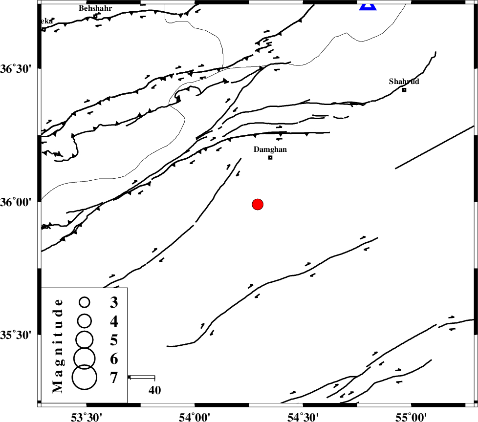
| Location | Lat:35.99 Lon: 54.29 |
| Region | Semnan Province, 20 km South of Damghan |
Nearest Cities |
|
| 13 km East of Amirabad, Semnan Province | |
| 15 km East of Seydabad, Semnan Province | |
| 20 km South of Damghan, Semnan Province | |
| 34 km East of Darvar, Semnan Province | |
| 35 km South West of Mehmandust, Semnan Province | |
| Depth | 16 km |
| Agency | |
Faults within 150 km: |
|
| ATARI_F (Length: 185 km) , Distance to epicenter: 19 km | |
| DAMGHAN_F (Length: 95 km) , Distance to epicenter: 27 km | |
| ASTANEH_F (Length: 72 km) , Distance to epicenter: 37 km | |
| Number of Phases | 10 |
| RMS | 0.4 |
| Number of Stations | 7 |
| Error in Latitude | >7.6 km |
| Error in Longitude | 2.5 km |
| Error in Depth | 6.6 km |
Download waveform in seisan format
to download seisan software Click here
to access information about IIEES stations Click here
Amplitude | ||||||||
| UID | Agency | Station | Component | Amplitude | Period | Arrival Time | Proccessing Time | Signal Clip |
| 92447 | IIEES | THKV | E | 73.2 | 0.25 | 2014-05-17 06:45:01 | 2014-05-17 08:11:00 | n |
| 92448 | IIEES | GHVR | E | 82 | 0.4 | 2014-05-17 06:45:09 | 2014-05-17 08:11:00 | n |
Phase | ||||||||||||
| Agency | Station | Component | Phase Type | Phase Quality | First Motion | Observed Arrival Time | Time Residual | Loc. Flag | Input Weight | Distance | Azimuth | |
| IIEES | SHRO | Z | Pg | E | 2014-05-17 06:43:54 | -0.56 | y | 156 | 89 | |||
| IIEES | SHRO | E | Sg | E | 2014-05-17 06:44:14 | 0.45 | y | 156 | 89 | |||
| IIEES | DAMV | Z | Pn | E | 2014-05-17 06:44:02 | -0.27 | y | 213 | 260 | |||
| IIEES | CHTH | Z | Pn | E | 2014-05-17 06:44:12 | 0.09 | y | 285 | 269 | |||
| IIEES | CHTH | N | Sg | E | 2014-05-17 06:44:49 | -0.15 | y | 285 | 269 | |||
| IIEES | THKV | Z | Pn | E | 2014-05-17 06:44:15 | 0.75 | y | 308 | 269 | |||
| IIEES | GHVR | Z | Pn | E | 2014-05-17 06:44:16 | -0.23 | y | 324 | 240 | |||
| IIEES | GHVR | N | Sg | E | 2014-05-17 06:45:00 | 0.28 | y | 324 | 240 | |||
| IIEES | TABS | Z | Pn | E | 2014-05-17 06:44:22 | -0.06 | y | 367 | 134 | |||
| IIEES | ASAO | Z | Pn | E | 2014-05-17 06:44:28 | -0.32 | y | 420 | 249 | |||