
Magnitude |
:3 |
| Date & Time (UTC) | 2014-05-15 22:37:21.4 |
| Date & Time (Local) | 1393/2/26 03:07:21.4 |
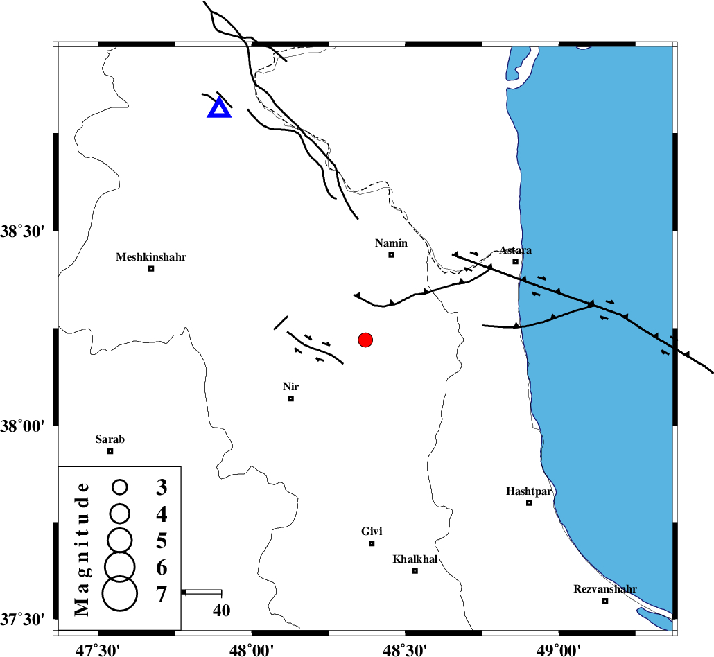
| Location | Lat:38.22 Lon: 48.37 |
| Region | Ardebil Province, 7 km Ardabil |
Nearest Cities |
|
| 6 km of Niar, Ardebil Province | |
| 7 km of Ardabil, Ardebil Province | |
| 14 km South of Kalkhoran, Ardebil Province | |
| 16 km North of Mehmandust, Ardebil Province | |
| 17 km North West of Hir, Ardebil Province | |
| Depth | 14 km |
| Agency | |
Faults within 150 km: |
|
| BOZQUSH (Length: 70 km) , Distance to epicenter: 14 km | |
| SANGAVAR_F (Length: 61 km) , Distance to epicenter: 16 km | |
| TALESH_F (Length: 258 km) , Distance to epicenter: 44 km | |
| Number of Phases | 7 |
| RMS | 0.3 |
| Number of Stations | 5 |
| Error in Latitude | >3.7 km |
| Error in Longitude | 7 km |
| Error in Depth | 6.5 km |
Download waveform in seisan format
to download seisan software Click here
to access information about IIEES stations Click here
Amplitude | ||||||||
| UID | Agency | Station | Component | Amplitude | Period | Arrival Time | Proccessing Time | Signal Clip |
| 92436 | IIEES | GRMI | E | 819.1 | 0.12 | 2014-05-15 22:37:45 | 2014-05-16 12:03:00 | n |
| 92437 | IIEES | ZNJK | E | 135.1 | 0.24 | 2014-05-15 22:38:13 | 2014-05-16 12:03:00 | n |
Phase | ||||||||||||
| Agency | Station | Component | Phase Type | Phase Quality | First Motion | Observed Arrival Time | Time Residual | Loc. Flag | Input Weight | Distance | Azimuth | |
| IIEES | GRMI | Z | Pg | E | 2014-05-15 22:37:34 | -0.33 | y | 77.7 | 328 | |||
| IIEES | ZNJK | Z | Pn | E | 2014-05-15 22:37:50 | -0.16 | y | 174 | 171 | |||
| IIEES | ZNJK | N | Sg | E | 2014-05-15 22:38:11 | -0.31 | y | 174 | 171 | |||
| IIEES | MAKU | Z | Pn | E | 2014-05-15 22:38:12 | 0.19 | y | 344 | 293 | |||
| IIEES | MAKU | N | Sg | E | 2014-05-15 22:38:58 | 0.06 | y | 344 | 293 | |||
| IIEES | SNGE | Z | Pn | E | 2014-05-15 22:38:14 | 0.18 | y | 359 | 195 | |||
| IIEES | ASAO | Z | Pn | E | 2014-05-15 22:38:23 | 0.58 | y | 433 | 159 | |||