
Magnitude |
:3.2 |
| Date & Time (UTC) | 2014-05-15 07:49:17.8 |
| Date & Time (Local) | 1393/2/25 12:19:17.8 |
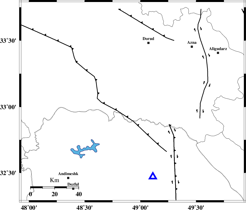
| Location | Lat:33.04 Lon: 48.93 |
| Region | Lorestan Province, 51 km South-West of Dorud |
Nearest Cities |
|
| 1 km of Bargsar, Lorestan Province | |
| 20 km South East of Chamsangar, Lorestan Province | |
| 26 km South of Sartang barzeh, Lorestan Province | |
| 28 km South West of Shulabad, Lorestan Province | |
| 29 km North East of Shuy, Khoozestan Province | |
| Depth | 6 km |
| Agency | |
Faults within 150 km: |
|
| HZF4 (Length: 492 km) , Distance to epicenter: 21 km | |
| MFF2 (Length: 205 km) , Distance to epicenter: 27 km | |
| BALARUD_F_Z2 (Length: 58 km) , Distance to epicenter: 35 km | |
| Number of Phases | 8 |
| RMS | 0.2 |
| Number of Stations | 7 |
| Error in Latitude | >2.5 km |
| Error in Longitude | 4.7 km |
| Error in Depth | 5.5 km |
Download waveform in seisan format
to download seisan software Click here
to access information about IIEES stations Click here
Amplitude | ||||||||
| UID | Agency | Station | Component | Amplitude | Period | Arrival Time | Proccessing Time | Signal Clip |
| 92432 | IIEES | SHGR | E | 619.2 | 0.29 | 2014-05-15 07:49:55 | 2014-05-15 09:25:00 | n |
| 92433 | IIEES | SHGR | N | 746.2 | 0.45 | 2014-05-15 07:49:55 | 2014-05-15 09:25:00 | n |
Phase | ||||||||||||
| Agency | Station | Component | Phase Type | Phase Quality | First Motion | Observed Arrival Time | Time Residual | Loc. Flag | Input Weight | Distance | Azimuth | |
| IIEES | SHGR | Z | Pg | E | 2014-05-15 07:49:35 | -0.34 | y | 104 | 187 | |||
| IIEES | SHGR | N | Sg | E | 2014-05-15 07:49:49 | 0.2 | y | 104 | 187 | |||
| IIEES | KHMZ | Z | Pg | E | 2014-05-15 07:49:39 | -0.05 | y | 124 | 51 | |||
| IIEES | ASAO | Z | Pn | E | 2014-05-15 07:49:51 | 0.31 | y | 196 | 31 | |||
| IIEES | GHVR | Z | Pn | E | 2014-05-15 07:49:59 | -0.1 | y | 268 | 53 | |||
| IIEES | SNGE | Z | Pn | E | 2014-05-15 07:50:00 | 0.06 | y | 271 | 328 | |||
| IIEES | CHTH | Z | Pn | E | 2014-05-15 07:50:13 | -0.12 | y | 377 | 32 | |||
| IIEES | DAMV | Z | Pn | E | 2014-05-15 07:50:16 | 0.02 | y | 401 | 43 | |||