
Magnitude |
:2.5 |
| Date & Time (UTC) | 2014-05-11 07:45:33.8 |
| Date & Time (Local) | 1393/2/21 12:15:33.8 |
| Location | Lat:31.53 Lon: 49.76 |
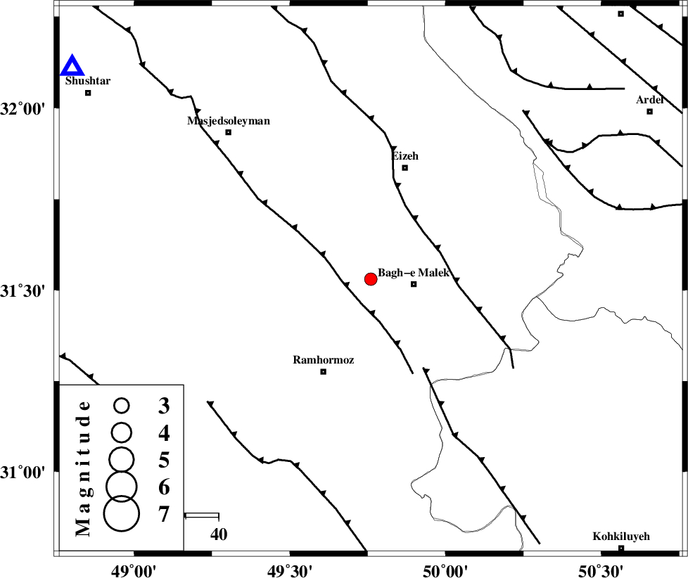
| Region | Khoozestan Province, 13 km West of Bagh Malek |
Nearest Cities |
|
| 10 km North of Midavood-e sofla, Khoozestan Province | |
| 13 km North West of Bagh Malek, Khoozestan Province | |
| 17 km South West of Ghaleh tal, Khoozestan Province | |
| 20 km East of Jaru, Khoozestan Province | |
| 22 km West of Abolabbas, Khoozestan Province | |
| Depth | 15 km |
| Agency | |
Faults within 150 km: |
|
| DEZFUL_EMBAYMENT (Length: 228 km) , Distance to epicenter: 8 km | |
| MFF2 (Length: 205 km) , Distance to epicenter: 21 km | |
| MFF4 (Length: 62 km) , Distance to epicenter: 31 km | |
| Number of Phases | 6 |
| RMS | 0.1 |
| Number of Stations | 4 |
| Error in Latitude | >3.7 km |
| Error in Longitude | 3.2 km |
| Error in Depth | 5.9 km |
Download waveform in seisan format
to download seisan software Click here
to access information about IIEES stations Click here
Amplitude | ||||||||
| UID | Agency | Station | Component | Amplitude | Period | Arrival Time | Proccessing Time | Signal Clip |
| 92393 | IIEES | SHGR | N | 114.3 | 0.25 | 2014-05-11 07:46:08 | 2014-05-11 09:23:00 | n |
| 92394 | IIEES | SHGR | E | 146.9 | 0.27 | 2014-05-11 07:46:08 | 2014-05-11 09:23:00 | n |
| 92395 | IIEES | KHMZ | E | 31.5 | 0.4 | 2014-05-11 07:46:47 | 2014-05-11 09:23:00 | n |
Phase | ||||||||||||
| Agency | Station | Component | Phase Type | Phase Quality | First Motion | Observed Arrival Time | Time Residual | Loc. Flag | Input Weight | Distance | Azimuth | |
| IIEES | SHGR | Z | Pg | E | 2014-05-11 07:45:52 | -0.01 | y | 111 | 305 | |||
| IIEES | SHGR | N | Sg | E | 2014-05-11 07:46:06 | 0.01 | y | 111 | 305 | |||
| IIEES | KHMZ | Z | Pn | E | 2014-05-11 07:46:12 | 0.09 | y | 245 | 4 | |||
| IIEES | KHMZ | E | Sg | E | 2014-05-11 07:46:43 | 0 | y | 245 | 4 | |||
| IIEES | ASAO | Z | Pn | E | 2014-05-11 07:46:23 | -0.15 | y | 335 | 4 | |||
| IIEES | GHVR | Z | Pn | E | 2014-05-11 07:46:25 | 0.05 | y | 355 | 23 | |||