
Magnitude |
:2.4 |
| Date & Time (UTC) | 2014-04-16 00:17:45.5 |
| Date & Time (Local) | 1393/1/27 04:47:45.5 |
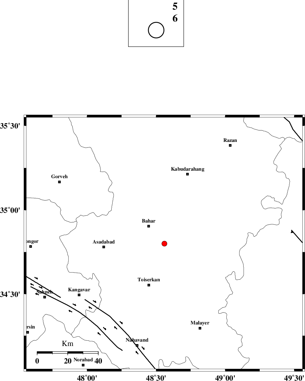
| Location | Lat:34.8 Lon: 48.56 |
| Region | Hamedan Province, 4 km Hamedan |
Nearest Cities |
|
| 4 km North of Abshineh, Hamedan Province | |
| 4 km North of Hamedan, Hamedan Province | |
| 8 km North of Qonjan, Hamedan Province | |
| 9 km of Jozqan, Hamedan Province | |
| 10 km East of Meriyanaj, Hamedan Province | |
| Depth | 14 km |
| Agency | |
Faults within 150 km: |
|
| NAHAVAND_F (Length: 102 km) , Distance to epicenter: 60 km | |
| SAHANEH_F (Length: 77 km) , Distance to epicenter: 71 km | |
| DINEHVAR_F (Length: 46 km) , Distance to epicenter: 77 km | |
| Number of Phases | 6 |
| RMS | 0.1 |
| Number of Stations | 3 |
| Error in Latitude | >3 km |
| Error in Longitude | 1.7 km |
| Error in Depth | 11.9 km |
Download waveform in seisan format
to download seisan software Click here
to access information about IIEES stations Click here
Amplitude | ||||||||
| UID | Agency | Station | Component | Amplitude | Period | Arrival Time | Proccessing Time | Signal Clip |
| 92235 | IIEES | SNGE | N | 120.4 | 0.16 | 2014-04-16 00:18:20 | 2014-04-16 03:27:00 | n |
| 92236 | IIEES | KHMZ | E | 38.8 | 0.24 | 2014-04-16 00:18:40 | 2014-04-16 03:27:00 | n |
Phase | ||||||||||||
| Agency | Station | Component | Phase Type | Phase Quality | First Motion | Observed Arrival Time | Time Residual | Loc. Flag | Input Weight | Distance | Azimuth | |
| IIEES | SNGE | Z | P | E | 2014-04-16 00:18:05 | 0.17 | y | 115 | 287 | |||
| IIEES | SNGE | N | Sg | E | 2014-04-16 00:18:19 | -0.11 | y | 115 | 287 | |||
| IIEES | ASAO | Z | Pg | E | 2014-04-16 00:18:08 | -0.09 | y | 138 | 101 | |||
| IIEES | ASAO | N | Sg | E | 2014-04-16 00:18:25 | 0.05 | y | 138 | 101 | |||
| IIEES | KHMZ | Z | Pg | E | 2014-04-16 00:18:14 | -0.05 | y | 175 | 132 | |||
| IIEES | KHMZ | N | Sg | E | 2014-04-16 00:18:35 | 0.03 | y | 175 | 132 | |||