
Magnitude |
:2.9 |
| Date & Time (UTC) | 2014-04-15 15:00:00.1 |
| Date & Time (Local) | 1393/1/26 19:30:00.1 |
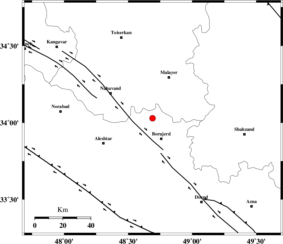
| Location | Lat:34.03 Lon: 48.69 |
| Region | Lorestan Province, 16 km North of Borujerd |
Nearest Cities |
|
| 3 km of Darre-ye gorg, Lorestan Province | |
| 4 km North of Ashtarinan, Lorestan Province | |
| 8 km North of Bon dizeh, Lorestan Province | |
| 13 km South of Kahakdan, Hamedan Province | |
| 13 km East of Jaefarabad, Lorestan Province | |
| Depth | 14 km |
| Agency | |
Faults within 150 km: |
|
| NAHAVAND_F (Length: 102 km) , Distance to epicenter: 15 km | |
| DORUD (Length: 100 km) , Distance to epicenter: 26 km | |
| SAHANEH_F (Length: 77 km) , Distance to epicenter: 42 km | |
| Number of Phases | 4 |
| RMS | 0.1 |
| Number of Stations | 4 |
| Error in Latitude | >5.2 km |
| Error in Longitude | 3.2 km |
| Error in Depth | 11 km |
Download waveform in seisan format
to download seisan software Click here
to access information about IIEES stations Click here
Amplitude | ||||||||
| UID | Agency | Station | Component | Amplitude | Period | Arrival Time | Proccessing Time | Signal Clip |
| 92230 | IIEES | ASAO | E | 182.2 | 0.4 | 2014-04-15 15:00:47 | 2014-04-15 04:22:00 | n |
| 92231 | IIEES | SHGR | N | 126.2 | 0.4 | 2014-04-15 15:01:02 | 2014-04-15 04:22:00 | n |
| 92232 | IIEES | SHGR | E | 132.2 | 0.4 | 2014-04-15 15:01:07 | 2014-04-15 04:22:00 | n |
Phase | ||||||||||||
| Agency | Station | Component | Phase Type | Phase Quality | First Motion | Observed Arrival Time | Time Residual | Loc. Flag | Input Weight | Distance | Azimuth | |
| IIEES | KHMZ | Z | Pg | E | 2014-04-15 15:00:20 | -0.12 | y | 123 | 105 | |||
| IIEES | ASAO | Z | Pg | E | 2014-04-15 15:00:23 | 0.09 | y | 136 | 65 | |||
| IIEES | SNGE | Z | Pg | E | 2014-04-15 15:00:28 | -0.04 | y | 170 | 314 | |||
| IIEES | SHGR | N | Pn | E | 2014-04-15 15:00:34 | 0.06 | y | 214 | 177 | |||