
Magnitude |
:2.9 |
| Date & Time (UTC) | 2014-04-11 07:17:38.2 |
| Date & Time (Local) | 1393/1/22 11:47:38.2 |
| Location | Lat:32.87 Lon: 48.59 |
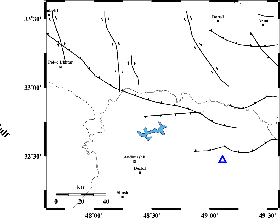
| Region | Khoozestan Province, 51 km North-East of Andimeshk |
Nearest Cities |
|
| 22 km North West of Shuy, Khoozestan Province | |
| 27 km North East of Sorkhakan, Khoozestan Province | |
| 35 km North East of Bidruyeh, Khoozestan Province | |
| 38 km South West of Bargsar, Lorestan Province | |
| 38 km North East of Hoseinieh, Khoozestan Province | |
| Depth | 29 km |
| Agency | |
Faults within 150 km: |
|
| BALARUD_F_Z2 (Length: 58 km) , Distance to epicenter: 5 km | |
| BALARUD_F_Z3 (Length: 53 km) , Distance to epicenter: 10 km | |
| MFF2 (Length: 205 km) , Distance to epicenter: 31 km | |
| Number of Phases | 5 |
| RMS | 0.1 |
| Number of Stations | 5 |
| Error in Latitude | >2.6 km |
| Error in Longitude | 3.8 km |
| Error in Depth | 4.7 km |
Download waveform in seisan format
to download seisan software Click here
to access information about IIEES stations Click here
Amplitude | ||||||||
| UID | Agency | Station | Component | Amplitude | Period | Arrival Time | Proccessing Time | Signal Clip |
| 92191 | IIEES | SHGR | N | 451.5 | 0.44 | 2014-04-11 07:18:13 | 2014-04-11 08:39:00 | n |
| 92192 | IIEES | SHGR | E | 433.5 | 0.68 | 2014-04-11 07:18:17 | 2014-04-11 08:39:00 | n |
| 92193 | IIEES | SNGE | N | 72.7 | 0.56 | 2014-04-11 07:18:58 | 2014-04-11 08:39:00 | n |
Phase | ||||||||||||
| Agency | Station | Component | Phase Type | Phase Quality | First Motion | Observed Arrival Time | Time Residual | Loc. Flag | Input Weight | Distance | Azimuth | |
| IIEES | SHGR | Z | Pg | E | 2014-04-11 07:17:53 | -0.01 | y | 87.2 | 167 | |||
| IIEES | KHMZ | Z | Pg | E | 2014-04-11 07:18:04 | 0.01 | y | 160 | 53 | |||
| IIEES | ASAO | Z | Pn | E | 2014-04-11 07:18:12 | -0.16 | y | 229 | 35 | |||
| IIEES | SNGE | Z | Pn | E | 2014-04-11 07:18:18 | 0.04 | y | 271 | 335 | |||
| IIEES | GHVR | Z | Pn | E | 2014-04-11 07:18:22 | 0.13 | y | 304 | 53 | |||