
Magnitude |
:3.2 |
| Date & Time (UTC) | 2014-03-30 10:02:23.0 |
| Date & Time (Local) | 1393/1/10 14:32:23.0 |
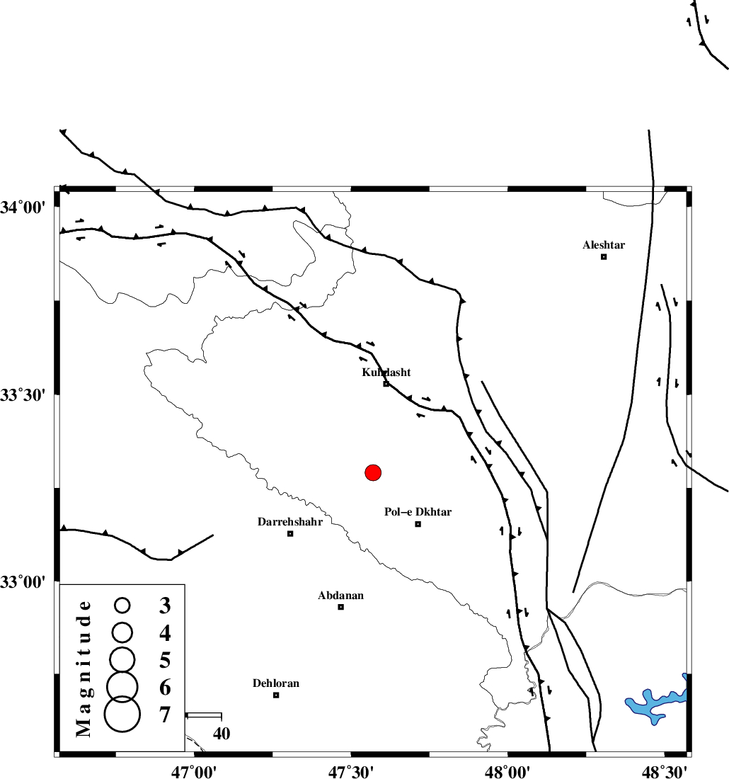
| Location | Lat:33.29 Lon: 47.57 |
| Region | Lorestan Province, 27 km South of Kuhdasht |
Nearest Cities |
|
| 9 km North of Chaqabol, Lorestan Province | |
| 13 km East of Suri, Lorestan Province | |
| 15 km North West of Morani, Lorestan Province | |
| 20 km North West of Pol-e dokhtar, Lorestan Province | |
| 24 km South of Ashtarheh golgol, Lorestan Province | |
| Depth | 14 km |
| Agency | |
Faults within 150 km: |
|
| BALARUD_F_Z1 (Length: 87 km) , Distance to epicenter: 36 km | |
| HZF4 (Length: 492 km) , Distance to epicenter: 57 km | |
| MFF6 (Length: 144 km) , Distance to epicenter: 65 km | |
| Number of Phases | 7 |
| RMS | 0.2 |
| Number of Stations | 5 |
| Error in Latitude | >2.9 km |
| Error in Longitude | 9.7 km |
| Error in Depth | 9.1 km |
Download waveform in seisan format
to download seisan software Click here
to access information about IIEES stations Click here
Amplitude | ||||||||
| UID | Agency | Station | Component | Amplitude | Period | Arrival Time | Proccessing Time | Signal Clip |
| 92093 | IIEES | SHGR | E | 348.3 | 0.69 | 2014-03-30 10:03:15 | 2014-03-30 11:33:00 | n |
| 92094 | IIEES | SHGR | N | 324.5 | 0.43 | 2014-03-30 10:03:17 | 2014-03-30 11:33:00 | n |
| 92095 | IIEES | ASAO | N | 71 | 0.38 | 2014-03-30 10:03:40 | 2014-03-30 11:33:00 | n |
Phase | ||||||||||||
| Agency | Station | Component | Phase Type | Phase Quality | First Motion | Observed Arrival Time | Time Residual | Loc. Flag | Input Weight | Distance | Azimuth | |
| IIEES | SHGR | Z | Pg | E | 2014-03-30 10:02:51 | -0.3 | y | 175 | 138 | |||
| IIEES | SHGR | N | Sg | E | 2014-03-30 10:03:12 | 0.11 | y | 175 | 138 | |||
| IIEES | KHMZ | Z | Pn | E | 2014-03-30 10:02:59 | 0.14 | y | 228 | 77 | |||
| IIEES | ASAO | Z | Pn | E | 2014-03-30 10:03:04 | 0.17 | y | 266 | 58 | |||
| IIEES | ASAO | N | Sg | E | 2014-03-30 10:03:38 | -0.13 | y | 266 | 58 | |||
| IIEES | GHVR | Z | Pn | E | 2014-03-30 10:03:16 | 0.31 | y | 364 | 68 | |||
| IIEES | CHTH | Z | Pn | E | 2014-03-30 10:03:24 | -0.33 | y | 436 | 47 | |||