
Magnitude |
:2.9 |
| Date & Time (UTC) | 2014-03-24 05:38:39.1 |
| Date & Time (Local) | 1393/1/4 10:08:39.1 |
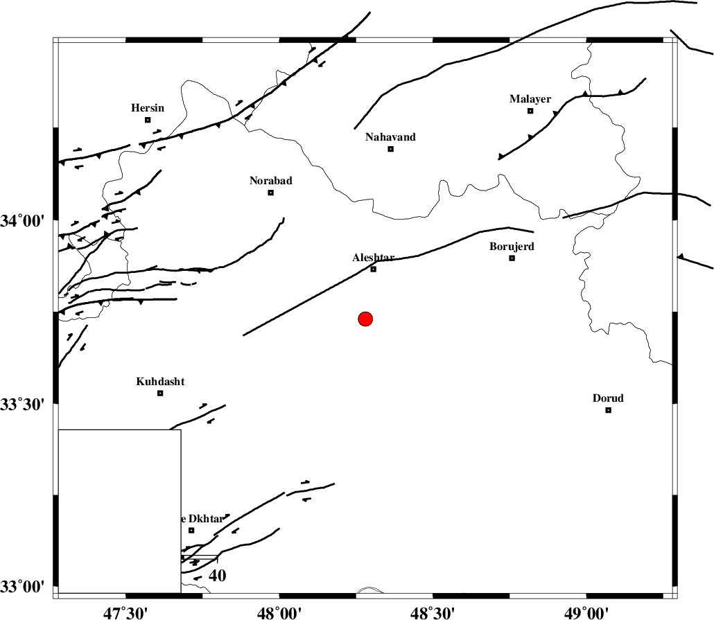
| Location | Lat:33.73 Lon: 48.28 |
| Region | Lorestan Province, 15 km South of Aleshtar |
Nearest Cities |
|
| 8 km of Siyahpush, Lorestan Province | |
| 14 km North of Rebat namaki, Lorestan Province | |
| 15 km South of Aleshtar, Lorestan Province | |
| 16 km South of Dehrahim, Lorestan Province | |
| 22 km South East of Firuz Abad, Lorestan Province | |
| Depth | 14 km |
| Agency | |
Faults within 150 km: |
|
| HZF4 (Length: 492 km) , Distance to epicenter: 22 km | |
| NAHAVAND_F (Length: 102 km) , Distance to epicenter: 39 km | |
| DORUD (Length: 100 km) , Distance to epicenter: 44 km | |
| Number of Phases | 9 |
| RMS | 0.2 |
| Number of Stations | 6 |
| Error in Latitude | >1.8 km |
| Error in Longitude | 3.7 km |
| Error in Depth | 4.8 km |
Download waveform in seisan format
to download seisan software Click here
to access information about IIEES stations Click here
Amplitude | ||||||||
| UID | Agency | Station | Component | Amplitude | Period | Arrival Time | Proccessing Time | Signal Clip |
| 92058 | IIEES | ASAO | N | 104.5 | 0.56 | 2014-03-24 05:39:37 | 2014-03-24 07:06:00 | n |
| 92059 | IIEES | SHGR | E | 142.9 | 0.66 | 2014-03-24 05:39:34 | 2014-03-24 07:06:00 | n |
Phase | ||||||||||||
| Agency | Station | Component | Phase Type | Phase Quality | First Motion | Observed Arrival Time | Time Residual | Loc. Flag | Input Weight | Distance | Azimuth | |
| IIEES | ASAO | Z | Pg | E | 2014-03-24 05:39:09 | -0.27 | y | 184 | 60 | |||
| IIEES | ASAO | N | Sg | E | 2014-03-24 05:39:31 | -0.11 | y | 184 | 60 | |||
| IIEES | SHGR | Z | Pg | E | 2014-03-24 05:39:09 | -0.08 | y | 187 | 165 | |||
| IIEES | SHGR | N | Sg | E | 2014-03-24 05:39:32 | 0.02 | y | 187 | 165 | |||
| IIEES | GHVR | Z | Pn | E | 2014-03-24 05:39:22 | 0 | y | 286 | 72 | |||
| IIEES | GHVR | N | Sg | E | 2014-03-24 05:39:59 | 0.12 | y | 286 | 72 | |||
| IIEES | ZNJK | Z | Pn | E | 2014-03-24 05:39:27 | -0.05 | y | 328 | 6 | |||
| IIEES | CHTH | Z | Pn | E | 2014-03-24 05:39:31 | 0.36 | y | 355 | 46 | |||
| IIEES | YZKH | Z | Pn | E | 2014-03-24 05:40:02 | 0.09 | y | 608 | 102 | |||