
Magnitude |
:3.5 |
| Date & Time (UTC) | 2014-03-20 11:13:22.5 |
| Date & Time (Local) | 1392/12/29 14:43:22.5 |
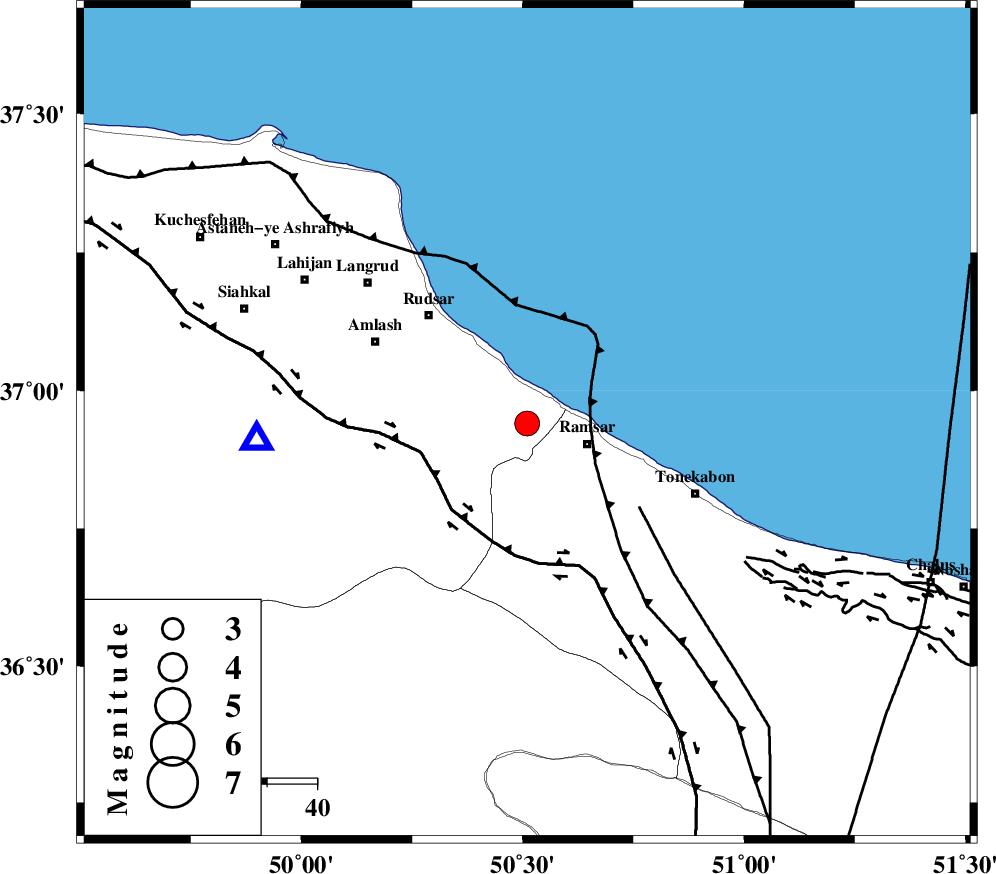
| Location | Lat:36.94 Lon: 50.51 |
| Region | Gilan Province, 13 km West of Ramsar |
Nearest Cities |
|
| 6 km of Chaboksar, Gilan Province | |
| 11 km North West of Galesh mahalleh, Mazandaran Province | |
| 13 km North West of Ramsar, Mazandaran Province | |
| 14 km East of Vajargah, Gilan Province | |
| 18 km East of Rahimabad, Gilan Province | |
| Depth | 31 km |
| Agency | |
Faults within 150 km: |
|
| KHAZAR_F (Length: 523 km) , Distance to epicenter: 4 km | |
| LAHIJAN_F (Length: 92 km) , Distance to epicenter: 25 km | |
| BONAN_F (Length: 74 km) , Distance to epicenter: 30 km | |
| Number of Phases | 5 |
| RMS | 0 |
| Number of Stations | 4 |
| Error in Latitude | >7.4 km |
| Error in Longitude | 3.3 km |
| Error in Depth | 3.1 km |
Download waveform in seisan format
to download seisan software Click here
to access information about IIEES stations Click here
Amplitude | ||||||||
| UID | Agency | Station | Component | Amplitude | Period | Arrival Time | Proccessing Time | Signal Clip |
| 92027 | IIEES | CHTH | N | 355.5 | 0.32 | 2014-03-20 11:13:59 | 2014-03-20 02:58:00 | n |
| 92028 | IIEES | ZNJK | E | 737.3 | 0.36 | 2014-03-20 11:14:09 | 2014-03-20 02:58:00 | n |
| 92029 | IIEES | ZNJK | N | 1152.2 | 0.48 | 2014-03-20 11:14:10 | 2014-03-20 02:58:00 | n |
Phase | ||||||||||||
| Agency | Station | Component | Phase Type | Phase Quality | First Motion | Observed Arrival Time | Time Residual | Loc. Flag | Input Weight | Distance | Azimuth | |
| IIEES | CHTH | Z | Pg | E | 2014-03-20 11:13:43 | 0 | y | 128 | 154 | |||
| IIEES | ZNJK | Z | Pg | E | 2014-03-20 11:13:49 | 0.01 | y | 165 | 260 | |||
| IIEES | ZNJK | N | Sg | E | 2014-03-20 11:14:09 | -0.01 | y | 165 | 260 | |||
| IIEES | ASAO | Z | Pn | E | 2014-03-20 11:14:02 | 0.04 | y | 269 | 189 | |||
| IIEES | GHVR | Z | Pn | E | 2014-03-20 11:14:03 | -0.04 | y | 281 | 166 | |||