
Magnitude |
:2.3 |
| Date & Time (UTC) | 2014-03-17 10:15:49.6 |
| Date & Time (Local) | 1392/12/26 13:45:49.6 |
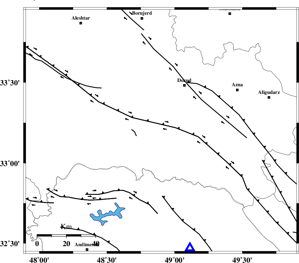
| Location | Lat:33.2 Lon: 48.9 |
| Region | Lorestan Province, 35 km South-West of Dorud |
Nearest Cities |
|
| 8 km North of Chamsangar, Lorestan Province | |
| 10 km of Sartang barzeh, Lorestan Province | |
| 17 km North of Bargsar, Lorestan Province | |
| 25 km North West of Shulabad, Lorestan Province | |
| 33 km South East of Emanabad, Lorestan Province | |
| Depth | 14 km |
| Agency | |
Faults within 150 km: |
|
| HZF4 (Length: 492 km) , Distance to epicenter: 10 km | |
| DORUD (Length: 100 km) , Distance to epicenter: 35 km | |
| MAIN_ZAGROS_R_F (Length: 1106 km) , Distance to epicenter: 38 km | |
| Number of Phases | 5 |
| RMS | 0.1 |
| Number of Stations | 3 |
| Error in Latitude | >3.3 km |
| Error in Longitude | 3.9 km |
| Error in Depth | 8.2 km |
Download waveform in seisan format
to download seisan software Click here
to access information about IIEES stations Click here
Amplitude | ||||||||
| UID | Agency | Station | Component | Amplitude | Period | Arrival Time | Proccessing Time | Signal Clip |
| 92010 | IIEES | KHMZ | N | 76 | 0.54 | 2014-03-17 10:16:29 | 2014-03-17 10:49:00 | n |
| 92011 | IIEES | ASAO | N | 34.5 | 0.6 | 2014-03-17 10:16:46 | 2014-03-17 10:49:00 | n |
| 92012 | IIEES | ASAO | E | 26.1 | 0.55 | 2014-03-17 10:16:47 | 2014-03-17 10:49:00 | n |
| 92013 | IIEES | SNGE | N | 26 | 0.66 | 2014-03-17 10:17:02 | 2014-03-17 10:49:00 | n |
| 92014 | IIEES | SNGE | E | 28.7 | 0.59 | 2014-03-17 10:17:08 | 2014-03-17 10:49:00 | n |
Phase | ||||||||||||
| Agency | Station | Component | Phase Type | Phase Quality | First Motion | Observed Arrival Time | Time Residual | Loc. Flag | Input Weight | Distance | Azimuth | |
| IIEES | KHMZ | Z | Pg | E | 2014-03-17 10:16:09 | -0.07 | y | 116 | 59 | |||
| IIEES | KHMZ | N | Sg | E | 2014-03-17 10:16:23 | 0.04 | y | 116 | 59 | |||
| IIEES | ASAO | Z | Pg | E | 2014-03-17 10:16:19 | 0.07 | y | 182 | 35 | |||
| IIEES | ASAO | E | Sg | E | 2014-03-17 10:16:41 | -0.04 | y | 182 | 35 | |||
| IIEES | SNGE | Z | Pn | E | 2014-03-17 10:16:29 | 0 | y | 254 | 326 | |||