
Magnitude |
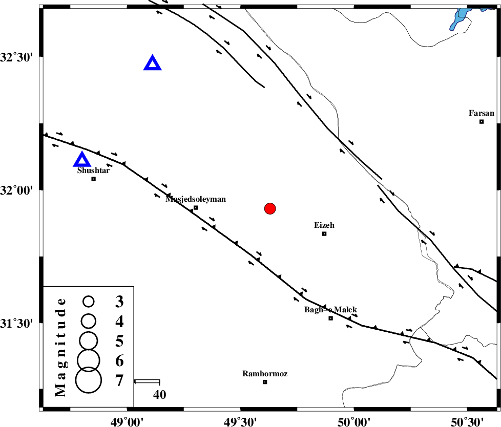
:3.1 |
| Date & Time (UTC) | 2014-03-16 23:49:27.6 |
| Date & Time (Local) | 1392/12/26 03:19:27.6 |
| Location | Lat:31.93 Lon: 49.63 |
| Region | Khoozestan Province, 31 km East of Masjed Soleyman |
Nearest Cities |
|
| 18 km North West of Rasvand, Khoozestan Province | |
| 20 km West of Torshak, Khoozestan Province | |
| 21 km North West of Chenarestan, Khoozestan Province | |
| 25 km North West of Izeh, Khoozestan Province | |
| 31 km East of Masjed Soleyman, Khoozestan Province | |
| Depth | 17 km |
| Agency | |
Faults within 150 km: |
|
| MFF2 (Length: 205 km) , Distance to epicenter: 12 km | |
| DEZFUL_EMBAYMENT (Length: 228 km) , Distance to epicenter: 30 km | |
| ZARDKUH_F (Length: 139 km) , Distance to epicenter: 57 km | |
| Number of Phases | 5 |
| RMS | 0 |
| Number of Stations | 4 |
| Error in Latitude | >2.2 km |
| Error in Longitude | 2.4 km |
| Error in Depth | 5.2 km |
Download waveform in seisan format
to download seisan software Click here
to access information about IIEES stations Click here
Amplitude | ||||||||
| UID | Agency | Station | Component | Amplitude | Period | Arrival Time | Proccessing Time | Signal Clip |
| 92005 | IIEES | KHMZ | E | 184.1 | 0.56 | 2014-03-16 23:50:34 | 2014-03-17 12:25:00 | n |
Phase | ||||||||||||
| Agency | Station | Component | Phase Type | Phase Quality | First Motion | Observed Arrival Time | Time Residual | Loc. Flag | Input Weight | Distance | Azimuth | |
| IIEES | SHGR | Z | Pg | E | 2014-03-16 23:49:41 | 0.01 | y | 80.7 | 284 | |||
| IIEES | SHGR | N | Sg | E | 2014-03-16 23:49:51 | -0.01 | y | 80.7 | 284 | |||
| IIEES | ASAO | Z | Pn | E | 2014-03-16 23:50:11 | 0.01 | y | 293 | 7 | |||
| IIEES | ASAO | E | Sg | E | 2014-03-16 23:50:50 | 0 | y | 293 | 7 | |||
| IIEES | YZKH | Z | Pn | E | 2014-03-16 23:50:33 | -0.01 | y | 471 | 82 | |||