
Magnitude |
:2 |
| Date & Time (UTC) | 2014-03-14 01:56:52.8 |
| Date & Time (Local) | 1392/12/23 05:26:52.8 |
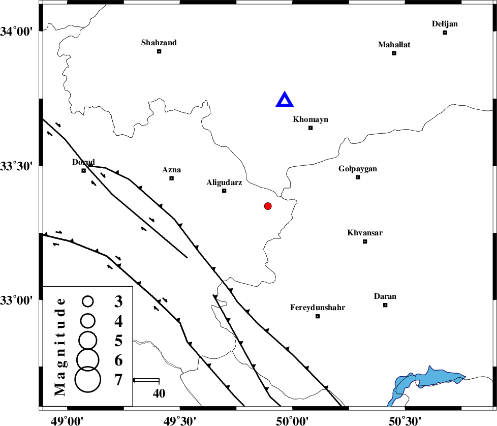
| Location | Lat:33.35 Lon: 49.89 |
| Region | Lorestan Province, 19 km East of Aligudarz |
Nearest Cities |
|
| 11 km North West of Halaghareh, Lorestan Province | |
| 12 km South of Dehnu, Markazi Province | |
| 19 km East of Aligudarz, Lorestan Province | |
| 20 km South of Farnaq, Markazi Province | |
| 20 km North East of Shapoorabad, Lorestan Province | |
| Depth | 7 km |
| Agency | |
Faults within 150 km: |
|
| MAIN_ZAGROS_R_F (Length: 1106 km) , Distance to epicenter: 34 km | |
| DORUD (Length: 100 km) , Distance to epicenter: 40 km | |
| ARDAL_F (Length: 170 km) , Distance to epicenter: 43 km | |
| Number of Phases | 6 |
| RMS | 0.1 |
| Number of Stations | 4 |
| Error in Latitude | >3.5 km |
| Error in Longitude | 2.3 km |
| Error in Depth | 5.7 km |
Download waveform in seisan format
to download seisan software Click here
to access information about IIEES stations Click here
Amplitude | ||||||||
| UID | Agency | Station | Component | Amplitude | Period | Arrival Time | Proccessing Time | Signal Clip |
| 91996 | IIEES | ASAO | N | 20.2 | 0.4 | 2014-03-14 01:57:38 | 2014-03-15 12:25:00 | n |
| 91997 | IIEES | GHVR | E | 21.3 | 0.48 | 2014-03-14 01:57:49 | 2014-03-15 12:25:00 | n |
| 91998 | IIEES | SNGE | N | 5.5 | 0.44 | 2014-03-14 01:58:24 | 2014-03-15 12:25:00 | n |
Phase | ||||||||||||
| Agency | Station | Component | Phase Type | Phase Quality | First Motion | Observed Arrival Time | Time Residual | Loc. Flag | Input Weight | Distance | Azimuth | |
| IIEES | KHMZ | Z | Pg | E | 2014-03-14 01:57:00 | 0.02 | y | 44.1 | 10 | |||
| IIEES | KHMZ | E | Sg | E | 2014-03-14 01:57:06 | 0.16 | y | 44.1 | 10 | |||
| IIEES | ASAO | N | Sg | E | 2014-03-14 01:57:32 | -0.14 | y | 134 | 6 | |||
| IIEES | GHVR | Z | Pn | E | 2014-03-14 01:57:23 | 0.03 | y | 178 | 45 | |||
| IIEES | GHVR | E | Sg | E | 2014-03-14 01:57:45 | -0.05 | y | 178 | 45 | |||
| IIEES | SNGE | Z | Pn | E | 2014-03-14 01:57:39 | -0.03 | y | 304 | 310 | |||