
Magnitude |
:3 |
| Date & Time (UTC) | 2014-03-06 01:48:02.4 |
| Date & Time (Local) | 1392/12/15 05:18:02.4 |
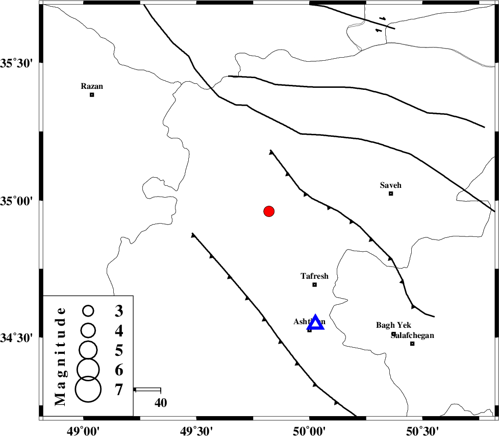
| Location | Lat:34.96 Lon: 49.82 |
| Region | Markazi Province, 35 km North-West of Tafresh |
Nearest Cities |
|
| 16 km North of Jaghtan, Markazi Province | |
| 17 km South of Gharqabad, Markazi Province | |
| 19 km South of Nobaran, Markazi Province | |
| 22 km North West of Bazarjan, Markazi Province | |
| 22 km West of Qeytaniyeh, Markazi Province | |
| Depth | 16 km |
| Agency | |
Faults within 150 km: |
|
| INDES_F (Length: 98 km) , Distance to epicenter: 15 km | |
| TAFRESH_F (Length: 117 km) , Distance to epicenter: 30 km | |
| KUSHK_E_NOSRAT_F (Length: 230 km) , Distance to epicenter: 34 km | |
| Number of Phases | 6 |
| RMS | 0.1 |
| Number of Stations | 5 |
| Error in Latitude | >1.8 km |
| Error in Longitude | 1.5 km |
| Error in Depth | 4.6 km |
Download waveform in seisan format
to download seisan software Click here
to access information about IIEES stations Click here
Amplitude | ||||||||
| UID | Agency | Station | Component | Amplitude | Period | Arrival Time | Proccessing Time | Signal Clip |
| 91932 | IIEES | GHVR | E | 255.1 | 0.6 | 2014-03-06 01:48:46 | 2014-03-06 02:15:00 | n |
Phase | ||||||||||||
| Agency | Station | Component | Phase Type | Phase Quality | First Motion | Observed Arrival Time | Time Residual | Loc. Flag | Input Weight | Distance | Azimuth | |
| IIEES | ASAO | Z | Pg | E | 2014-03-06 01:48:11 | -0.06 | y | 49.3 | 157 | |||
| IIEES | KHMZ | Z | Pg | E | 2014-03-06 01:48:25 | -0.09 | y | 136 | 174 | |||
| IIEES | GHVR | Z | Pg | E | 2014-03-06 01:48:26 | 0.21 | y | 141 | 112 | |||
| IIEES | CHTH | Z | Pg | E | 2014-03-06 01:48:28 | -0.11 | y | 159 | 48 | |||
| IIEES | SNGE | Z | Pn | E | 2014-03-06 01:48:38 | -0.01 | y | 226 | 274 | |||
| IIEES | SNGE | N | Sg | E | 2014-03-06 01:49:06 | 0.05 | y | 226 | 274 | |||