
Magnitude |
:2.2 |
| Date & Time (UTC) | 2014-03-02 06:04:24.5 |
| Date & Time (Local) | 1392/12/11 09:34:24.5 |
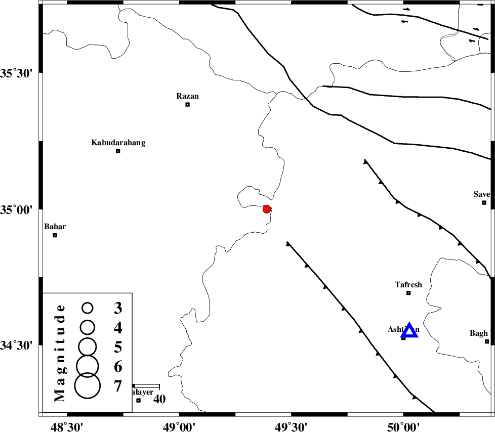
| Location | Lat:35 Lon: 49.39 |
| Region | Hamedan Province, 53 km South-East of Razan |
Nearest Cities |
|
| 17 km North of Vafs, Markazi Province | |
| 18 km South East of Tajrak, Hamedan Province | |
| 28 km North of Komijan, Markazi Province | |
| 28 km South West of Yatan, Markazi Province | |
| 30 km North West of Khanjin, Markazi Province | |
| Depth | 14 km |
| Agency | |
Faults within 150 km: |
|
| TAFRESH_F (Length: 117 km) , Distance to epicenter: 16 km | |
| INDES_F (Length: 98 km) , Distance to epicenter: 45 km | |
| KUSHK_E_NOSRAT_F (Length: 230 km) , Distance to epicenter: 46 km | |
| Number of Phases | 7 |
| RMS | 0.1 |
| Number of Stations | 5 |
| Error in Latitude | >2 km |
| Error in Longitude | 1.4 km |
| Error in Depth | 8.2 km |
Download waveform in seisan format
to download seisan software Click here
to access information about IIEES stations Click here
Amplitude | ||||||||
| UID | Agency | Station | Component | Amplitude | Period | Arrival Time | Proccessing Time | Signal Clip |
| 91902 | IIEES | ASAO | E | 93.1 | 0.26 | 2014-03-02 06:04:47 | 2014-03-02 08:02:00 | n |
| 91903 | IIEES | GHVR | E | 36.6 | 0.29 | 2014-03-02 06:05:20 | 2014-03-02 08:02:00 | n |
| 91904 | IIEES | GHVR | N | 34.9 | 0.23 | 2014-03-02 06:05:20 | 2014-03-02 08:02:00 | n |
Phase | ||||||||||||
| Agency | Station | Component | Phase Type | Phase Quality | First Motion | Observed Arrival Time | Time Residual | Loc. Flag | Input Weight | Distance | Azimuth | |
| IIEES | ASAO | Z | Pg | E | 2014-03-02 06:04:38 | 0.03 | y | 76.8 | 130 | |||
| IIEES | KHMZ | Z | Pg | E | 2014-03-02 06:04:49 | -0.09 | y | 149 | 159 | |||
| IIEES | KHMZ | E | S | E | 2014-03-02 06:05:07 | 0.07 | y | 149 | 159 | |||
| IIEES | GHVR | Z | Pg | E | 2014-03-02 06:04:54 | 0.12 | y | 180 | 108 | |||
| IIEES | GHVR | E | Sg | E | 2014-03-02 06:05:15 | -0.16 | y | 180 | 108 | |||
| IIEES | SNGE | Z | Pg | E | 2014-03-02 06:04:55 | -0.05 | y | 187 | 274 | |||
| IIEES | CHTH | Z | Pg | E | 2014-03-02 06:04:55 | 0.08 | y | 187 | 57 | |||