
Magnitude |
:3 |
| Date & Time (UTC) | 2014-02-17 03:12:21.6 |
| Date & Time (Local) | 1392/11/28 06:42:21.6 |
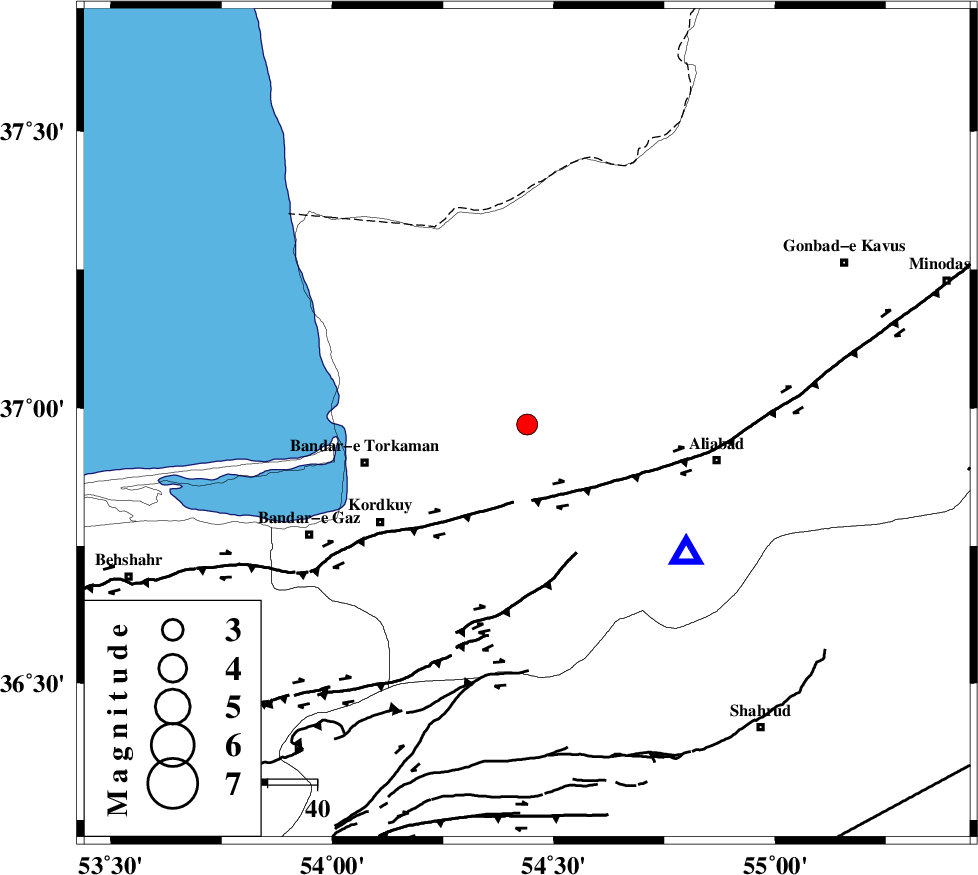
| Location | Lat:36.97 Lon: 54.44 |
| Region | Golestan Province, 4 km Aq Qaleh |
Nearest Cities |
|
| 5 km of Aq Qaleh, Golestan Province | |
| 8 km of Qanqarmeh, Golestan Province | |
| 13 km West of Nodeh malek, Golestan Province | |
| 15 km North of Gorgan, Golestan Province | |
| 17 km North West of Jalin olia, Golestan Province | |
| Depth | 18 km |
| Agency | |
Faults within 150 km: |
|
| KHAZAR_F (Length: 523 km) , Distance to epicenter: 14 km | |
| N_ALBORZ_F (Length: 360 km) , Distance to epicenter: 40 km | |
| SHAVAR_F (Length: 87 km) , Distance to epicenter: 45 km | |
| Number of Phases | 6 |
| RMS | 0 |
| Number of Stations | 4 |
| Error in Latitude | >1.9 km |
| Error in Longitude | 2.2 km |
| Error in Depth | 5.2 km |
Download waveform in seisan format
to download seisan software Click here
to access information about IIEES stations Click here
Amplitude | ||||||||
| UID | Agency | Station | Component | Amplitude | Period | Arrival Time | Proccessing Time | Signal Clip |
| 91812 | IIEES | THKV | E | 45.5 | 0.56 | 2014-02-17 03:13:57 | 2014-02-17 03:46:00 | n |
Phase | ||||||||||||
| Agency | Station | Component | Phase Type | Phase Quality | First Motion | Observed Arrival Time | Time Residual | Loc. Flag | Input Weight | Distance | Azimuth | |
| IIEES | SHRO | E | Pg | E | 2014-02-17 03:12:50 | 0.08 | y | 177 | 127 | |||
| IIEES | SHRO | E | Sg | E | 2014-02-17 03:13:12 | -0.05 | y | 177 | 127 | |||
| IIEES | BJRD | Z | Pn | E | 2014-02-17 03:13:03 | -0.04 | y | 275 | 72 | |||
| IIEES | BJRD | E | Sg | E | 2014-02-17 03:13:39 | 0.01 | y | 275 | 72 | |||
| IIEES | CHTH | Z | Pn | E | 2014-02-17 03:13:08 | 0.01 | y | 320 | 249 | |||
| IIEES | THKV | Z | Pn | E | 2014-02-17 03:13:11 | -0.02 | y | 340 | 251 | |||