
Magnitude |
:2.5 |
| Date & Time (UTC) | 2014-02-12 05:07:04.7 |
| Date & Time (Local) | 1392/11/23 08:37:04.7 |
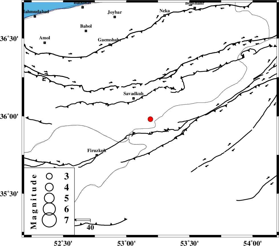
| Location | Lat:35.98 Lon: 53.19 |
| Region | Mazandaran Province, 19 km South-East of Pol-E-Sefid |
Nearest Cities |
|
| 10 km of Sangdeh, Mazandaran Province | |
| 12 km North of Chashem, Semnan Province | |
| 18 km South East of Shurmast-e peyrudbar, Mazandaran Province | |
| 19 km South East of Pol-E-Sefid, Mazandaran Province | |
| 23 km South East of Elahband, Mazandaran Province | |
| Depth | 16 km |
| Agency | |
Faults within 150 km: |
|
| N_ALBORZ_F (Length: 360 km) , Distance to epicenter: 25 km | |
| ATARI_F (Length: 185 km) , Distance to epicenter: 33 km | |
| KHAZAR_F (Length: 523 km) , Distance to epicenter: 57 km | |
| Number of Phases | 5 |
| RMS | 0.2 |
| Number of Stations | 5 |
| Error in Latitude | >5.3 km |
| Error in Longitude | 5.6 km |
| Error in Depth | 8.6 km |
Download waveform in seisan format
to download seisan software Click here
to access information about IIEES stations Click here
Amplitude | ||||||||
| UID | Agency | Station | Component | Amplitude | Period | Arrival Time | Proccessing Time | Signal Clip |
| 91783 | IIEES | THKV | E | 28.4 | 0.29 | 2014-02-12 05:08:08 | 2014-02-12 06:03:00 | n |
| 91784 | IIEES | GHVR | N | 38.4 | 0.41 | 2014-02-12 05:08:19 | 2014-02-12 06:03:00 | n |
| 91785 | IIEES | GHVR | E | 29.9 | 0.33 | 2014-02-12 05:08:20 | 2014-02-12 06:03:00 | n |
Phase | ||||||||||||
| Agency | Station | Component | Phase Type | Phase Quality | First Motion | Observed Arrival Time | Time Residual | Loc. Flag | Input Weight | Distance | Azimuth | |
| IIEES | CHTH | Z | Pg | E | 2014-02-12 05:07:35 | 0.05 | y | 186 | 268 | |||
| IIEES | GHVR | Z | Pn | E | 2014-02-12 05:07:42 | 0.39 | y | 243 | 227 | |||
| IIEES | GHVR | E | Sg | E | 2014-02-12 05:08:13 | -0.05 | y | 243 | 227 | |||
| IIEES | ASAO | Z | Pn | E | 2014-02-12 05:07:52 | -0.39 | y | 329 | 242 | |||
| IIEES | TABS | Z | Pn | E | 2014-02-12 05:08:07 | -0.06 | y | 443 | 125 | |||