
Magnitude |
:2.9 |
| Date & Time (UTC) | 2014-02-05 07:51:03.1 |
| Date & Time (Local) | 1392/11/16 11:21:03.1 |
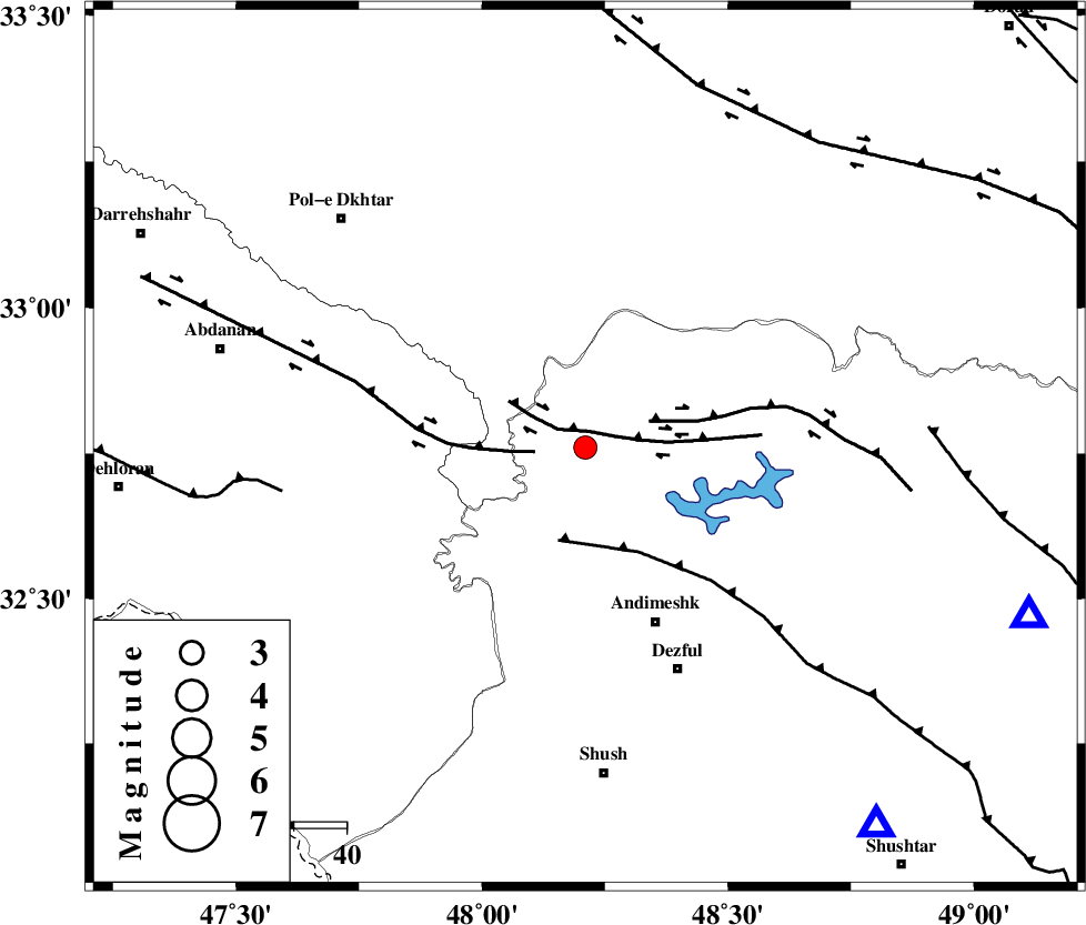
| Location | Lat:32.76 Lon: 48.21 |
| Region | Khoozestan Province, 36 km North-West of Andimeshk |
Nearest Cities |
|
| 3 km North of Bidruyeh, Khoozestan Province | |
| 10 km North of Hoseinieh, Khoozestan Province | |
| 11 km West of Sorkhakan, Khoozestan Province | |
| 36 km North West of Andimeshk, Khoozestan Province | |
| 46 km North West of Dezful, Khoozestan Province | |
| Depth | 14 km |
| Agency | |
Faults within 150 km: |
|
| BALARUD_F_Z3 (Length: 53 km) , Distance to epicenter: 3 km | |
| BALARUD_F_Z1 (Length: 87 km) , Distance to epicenter: 10 km | |
| BALARUD_F_Z2 (Length: 58 km) , Distance to epicenter: 13 km | |
| Number of Phases | 6 |
| RMS | 0.2 |
| Number of Stations | 5 |
| Error in Latitude | >3.6 km |
| Error in Longitude | 6.5 km |
| Error in Depth | 9 km |
Download waveform in seisan format
to download seisan software Click here
to access information about IIEES stations Click here
Amplitude | ||||||||
| UID | Agency | Station | Component | Amplitude | Period | Arrival Time | Proccessing Time | Signal Clip |
| 91733 | IIEES | SHGR | N | 360 | 0.45 | 2014-02-05 07:51:37 | 2014-02-05 08:21:00 | n |
| 91734 | IIEES | ASAO | E | 54.6 | 0.5 | 2014-02-05 07:52:26 | 2014-02-05 08:21:00 | n |
| 91735 | IIEES | ASAO | N | 137.6 | 0.9 | 2014-02-05 07:52:26 | 2014-02-05 08:21:00 | n |
| 91736 | IIEES | GHVR | E | 26.1 | 0.57 | 2014-02-05 07:52:34 | 2014-02-05 08:21:00 | n |
Phase | ||||||||||||
| Agency | Station | Component | Phase Type | Phase Quality | First Motion | Observed Arrival Time | Time Residual | Loc. Flag | Input Weight | Distance | Azimuth | |
| IIEES | SHGR | Z | Pg | E | 2014-02-05 07:51:18 | -0.02 | y | 91.2 | 142 | |||
| IIEES | KHMZ | Z | Pg | E | 2014-02-05 07:51:35 | -0.15 | y | 197 | 56 | |||
| IIEES | KHMZ | E | Sg | E | 2014-02-05 07:51:59 | -0.06 | y | 197 | 56 | |||
| IIEES | ASAO | Z | Pn | E | 2014-02-05 07:51:43 | 0.53 | y | 261 | 40 | |||
| IIEES | SNGE | Z | Pn | E | 2014-02-05 07:51:44 | -0.18 | y | 271 | 343 | |||
| IIEES | GHVR | Z | Pn | E | 2014-02-05 07:51:52 | -0.15 | y | 341 | 55 | |||